Digital Twins or Triplets

Raj. Thampuran
Managing Director
Technology and Research
Group R&D

A “pretty large bang” was heard by the crew of Apollo 13 two days after their launch from the Kennedy Space Centre on 11th April 1970. This was followed by the immortal words “Okay, Houston, we’ve had a problem here”. The ignition and blast from an exposed wire inside an oxygen tank heralded a dramatic rescue by Mission Control in Houston 330,000 km away. The subsequent four-day odyssey home for the space shuttle was the quintessential “what can go wrong; will go wrong”. As has been said about that mission; “no one has been in this amount of trouble so far from home”.

There are many heroes in a rescue mission of this complexity. One of them is surely a “digital twin”. 15 simulators were connected to computers able to replicate the response to an immense number of technical permutations which would guide the craft home after circling the moon. The space shuttle and its crew landed safely in the Pacific Ocean on 17th April.

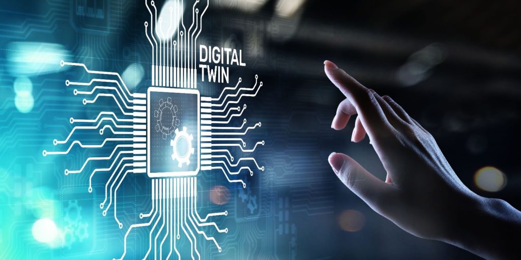
Today, a Google search for “digital twin” exceeds 300,000,000 results! Simply, it is the virtual representation (if you like, an avatar) of a physical system in real time. The idea is that the digital twin inhabits and exhibits the realities of a physical asset.

While technology progresses, its use is determined by cultures and people. In a fast paced, ever-changing digital era, not surprisingly for some, digital twins pervade many industries and aspects of private life today. Concepts in Industry 4.0 use digital twins in factory operations to monitor machine performance and spot problems. There are digital twins of hospitals, medical equipment and even human organs. Formula One racing is dominated by digital twins that predict problems, rectify difficulties and optimise the cars during an ultrahigh speed race. With over a hundred sensors in each car, billions of data (of tyre pressures, temperature, drag, acceleration, shifts in the locus of gravity, cockpit conditions) are transmitted via telemetry to remote command centres.

Neither is the built environment industry the last bastion to witness the influence of digital twins that will shape and transform its future. Digital twins will follow any industry impacted by big data. In fact, well before the built environment practice universally shifts from the classical use of two dimensional drawings and physical models to three dimensional, “living” models across the continuum of workflows, the profound value of the existence of information from these twins is already known.

In April 2019, the 12th century French Notre Dame Cathedral was ravaged by a devastating fire. The heroic work of a Vassar Professor, the late Andrew Tallon and his digital twin, restoring the Cathedral to its original design is now a realistic goal. Five years ago, in 2015, Professor Tallon used lasers to create point clouds of the Cathedral’s interior and exterior facades replete with gargoyles and spires. This is today the basis of the 3D digital rendering used in restoring this historical building.

Twins are Triplets in many ways. One of which is that their “DNA” depends on sophisticated software codes, data absorption abilities and pattern recognition (through machine learning or artificial intelligence). There are also commentators who describe twins as cyber, physical and social triplets because their properties manifest in all three realms. However it is viewed, what enables digital twins is the same technologies that propelled so many other revolutions: faster processing speeds, near unquenchable data ingestion capacities, cheap sensors’ ultra-integrated networks, communications rates and bandwidth, data storage, precocious analytical tools and new visualization techniques that allow the physical and digital worlds to meld and blend.

One way to think about the value of digital twins is its ability to participate in the entire built environment industry’s asset life cycle through concept, design, development, project management, construction and managed services. Take the example of the Virtual SingaporeTM platform. There has been much adulation in the media about Singapore’s vision to model and simulate the pulse of a vibrant city. The platform is surfeit with geospatial data about the city-state. It intends, when completed, to provide a digital space and experimental commons to make policy and design decisions, test hypotheses about urban systems and their interdependencies, model environmental impact on the landscape temporally and study community engagements in townships and its surroundings. It is an ambitious digital twin project made successful only by organisations and people able to harness its value.

With Surbana Jurong’s (SJ) domain expertise in the built environment, we have generated 3D models, large scale simulations and high dimensionality building information modelling (BIM) systems in a wide array of areas such as transport, flood control, engineering, masterplanning, design and asset management. And with our ability to incorporate data ingestion, digital twins have also been created. For instance, SJ’s VR City platform (see illustrations 1a, 1b & 1c) is a solution to test infrastructure and its design in response to connections and neighbouring dependencies. On it, changes can be made in a myriad of ways and candidate solutions derived through better information and consequently, preferred outcomes. The vision is to simulate a smart, conscious city that constantly monitors, among other factors, ambient conditions, traffic, accidents, emergencies, commuter and pedestrian patterns. Information is then channeled to an integrated operations centre and the appropriate responses transmitted to the relevant people or agencies.

Illustration 1 – SJ VR City can integrate a variety of data sources and is a convenient platform for urban planners to visualize and study the environment

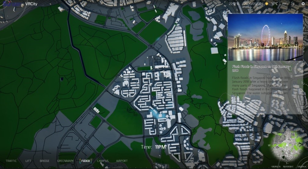
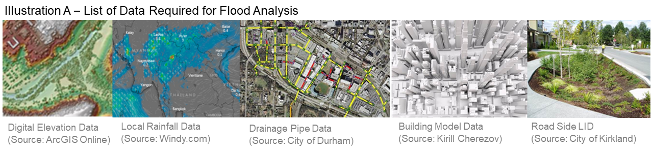
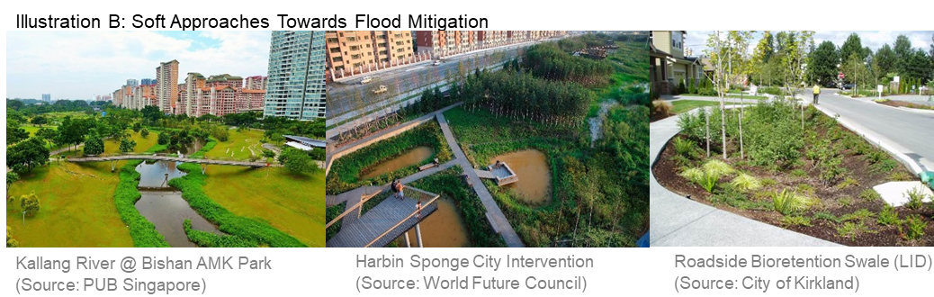
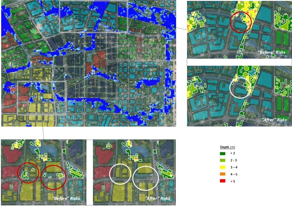
Illustration 1a – Flood simulation analysis – use of stormwater management model integrated into 3D model to identify vulnerable regions prone to flooding.

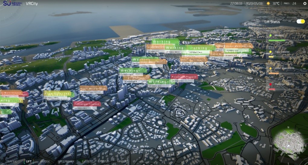
Illustration 1b – In city-wide lift or critical M&E asset monitoring, users will have a pictorial overview of asset status and condition and drill-in to the individual asset as necessary to query or activate a follow-up.

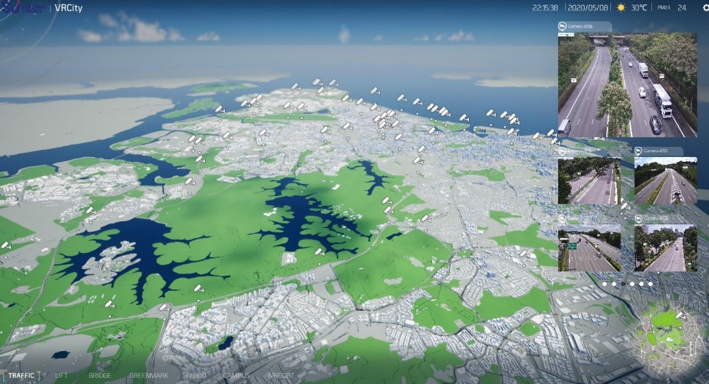
Illustration 1c – Traffic monitoring with associated video analytics allows users to zoom in to road conditions or troubled spots to advise on diversionary routes to ease congestion or assist police in tracking rouge vehicles.

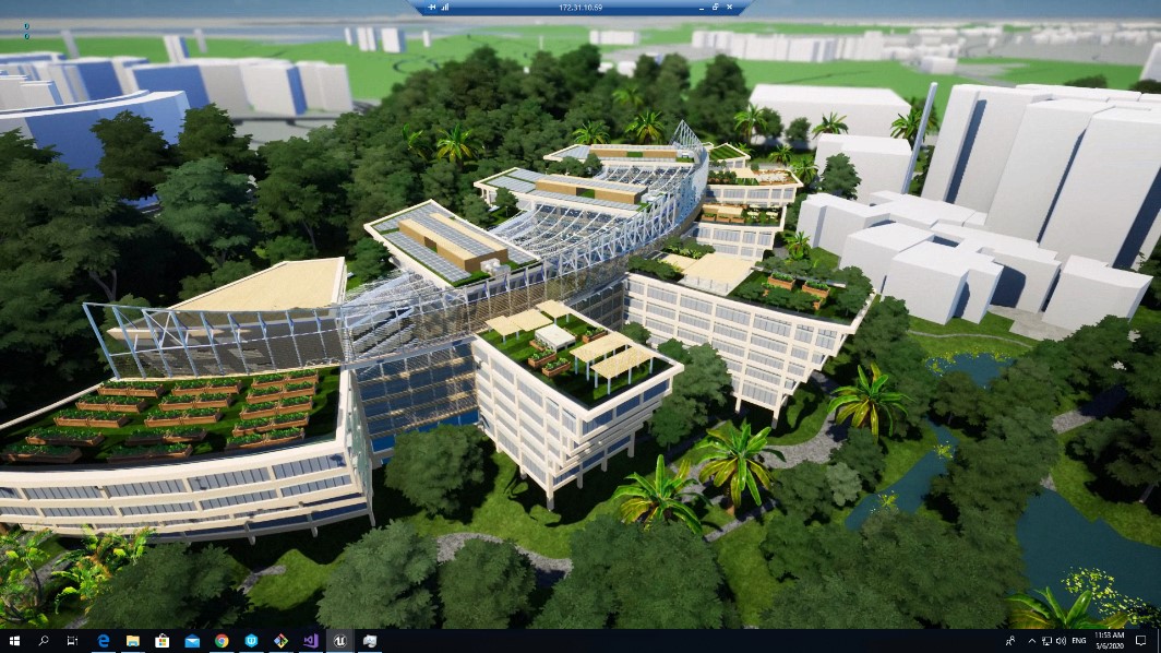
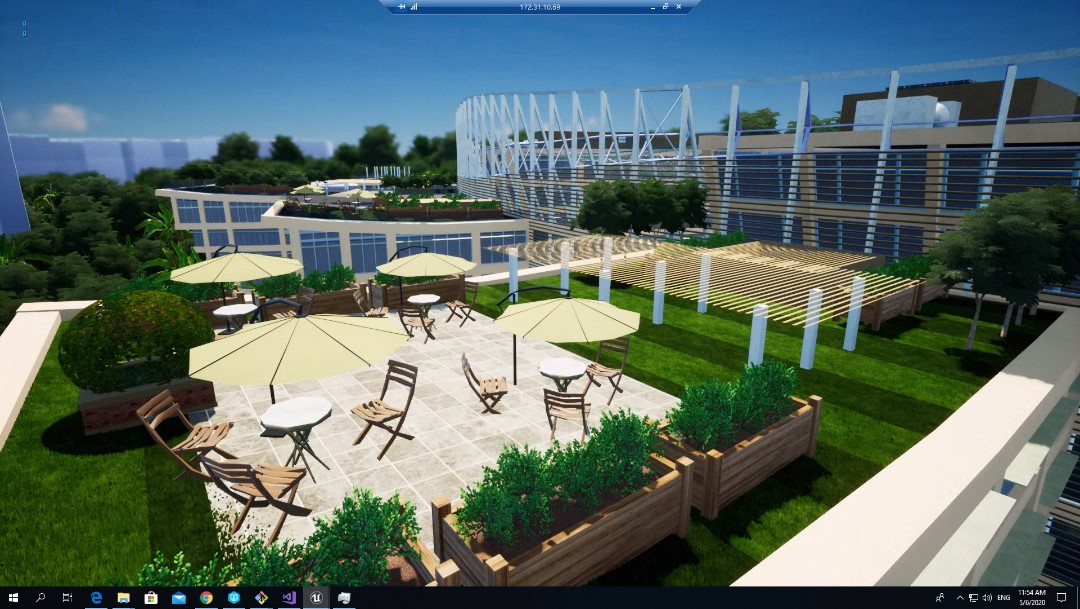
We are creating digital twins of our Moshe Safdie-designed SJ Campus harnessing the power of BIM, IoT, artificial intelligence, integrated digital delivery, sensor networks and new age visualisation tools (see illustrations 2a & 2b). To accomplish an equilibrium from many complex factors, the campus demonstrates the use of integrated twins from concept to construction, to long term maintenance. The aim is to create a balanced tropical ecology of light and shade, cooling and radiation deflection, and excellent air circulation and quality. The campus will become a living, pulsating laboratory responding to internal and external ambient factors and always sentient.

Illustrations 2a & 2b – Creating digital twins of Moshe Safdie-designed SJ Campus harnessing the power of BIM, IoT, artificial intelligence, integrated digital delivery, sensor networks and new age visualisation tools.

The constituents of cities and campuses are physical assets – some critical ones such as lifts, airports or hospitals – whose properties are embodied by their twins. If these constituents, each as digital twins, are connected, a digital thread is created. This gives us a glimpse of a future where the connected twins can collaborate with each other, share information and respond in ways that optimise the properties of the group or network. Therefore, in SJ, we embrace a multi-scale, multi-functionality, multidisciplinary strategy to our development of digital twins and its associated technologies. This way, our culture of ideas, creativity and collaboration is not limited by technologies or disciplinary specialisations.

The attractiveness of digital twins should not of course disguise difficulties. One inhibitor is the cost of creating and maintaining digital twin assets. This presents an opportunity for a business model innovation for consultants to become custodians and managers of digital assets for their clients. Providing services that governs and regularly improves data security, storage and integrity enhances model quality, refreshes technology and acts on other important factors of managing the twin.  There is substantial evidence of an industry that has rapidly burgeoned in a short period offering digital twin development services. Another that offers twin and digital asset management and quality assurance services will surely emerge soon, perhaps akin to another data management and applications hosting industry known as cloud service providers.

Digital twins or triplets, quadruplets or siblings, virtual avatars have emerged from the realms of imagination to reality in businesses. Ultimately, as history has proven, companies that are adept at creating, using, innovating and improving through technologies like digital twins will have distinct and formidable advantages over those less able.

** End **

Connect with Us

Raj. Thampuran
Email: raj.thampuran@surbanajurong.com

A Slideshow: Digital Technology Investments A Differentiator Amidst Crisis

This slideshow was adapted from an earlier article.

Digital Technology Investments A Differentiator Amidst Crisis

By Eugene Seah
Senior Director, Special Projects
Surbana Jurong Group

The COVID-19 outbreak is global, and increasing in intensity. Stringent measures have been adopted around the world to contain the virus, severely limiting economic activity. This has put a strain on many industries including the built environment industry, disrupting operations and forcing delays. In trying times like this, investments in digital technologies become a great differentiator.

The Building and Construction Authority (BCA) of Singapore first announced the adoption of Integrated Digital Delivery (IDD) plans for the built environment industry in November 2018. Since then, it has encouraged companies to digitise their processes and adopt productivity enhancing tools including ‘Cloud’ technologies.

In tandem with BCA’s efforts, Surbana Jurong (SJ) has accelerated its adoption of innovative technologies for various aspects of its business. The benefits are showing in the current crisis.

We flipped a switch and activated our Business Continuity Planning at a moment’s notice. With the segregation of teams, enterprise-grade virtual meeting technologies like Zoom, Microsoft Teams and Skype for Business (refer to Illustration A), have given teams across the organisation, globally, the ability to conduct meetings as if everyone was in the same room. At the same time, monitoring or inspecting construction projects for project managers can be done remotely through the use of cameras and even drones (refer to Illustration B). High quality construction cameras allow project managers a thorough view of construction activities and operations.

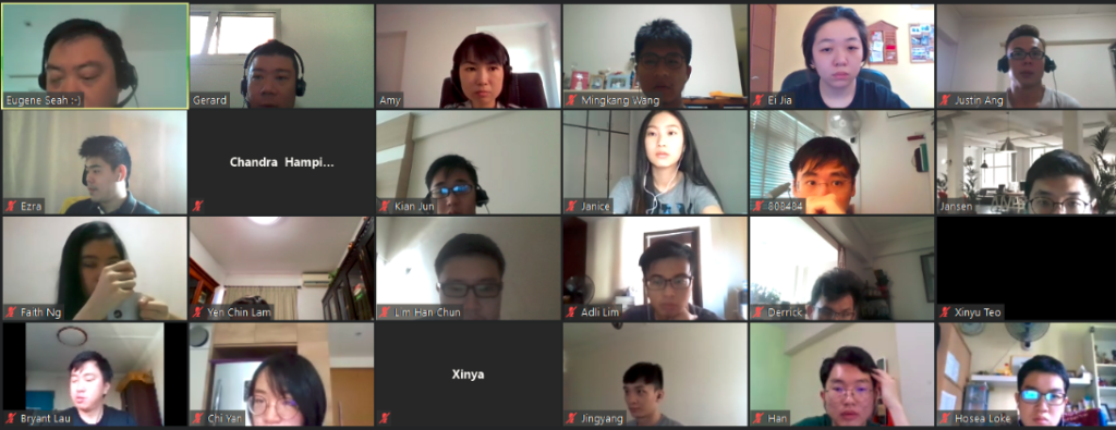
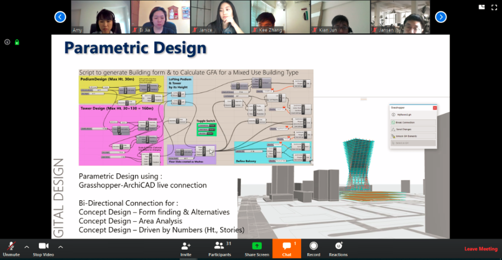
Illustration A: Staff of SJ undergoing graduate development programme using Zoom

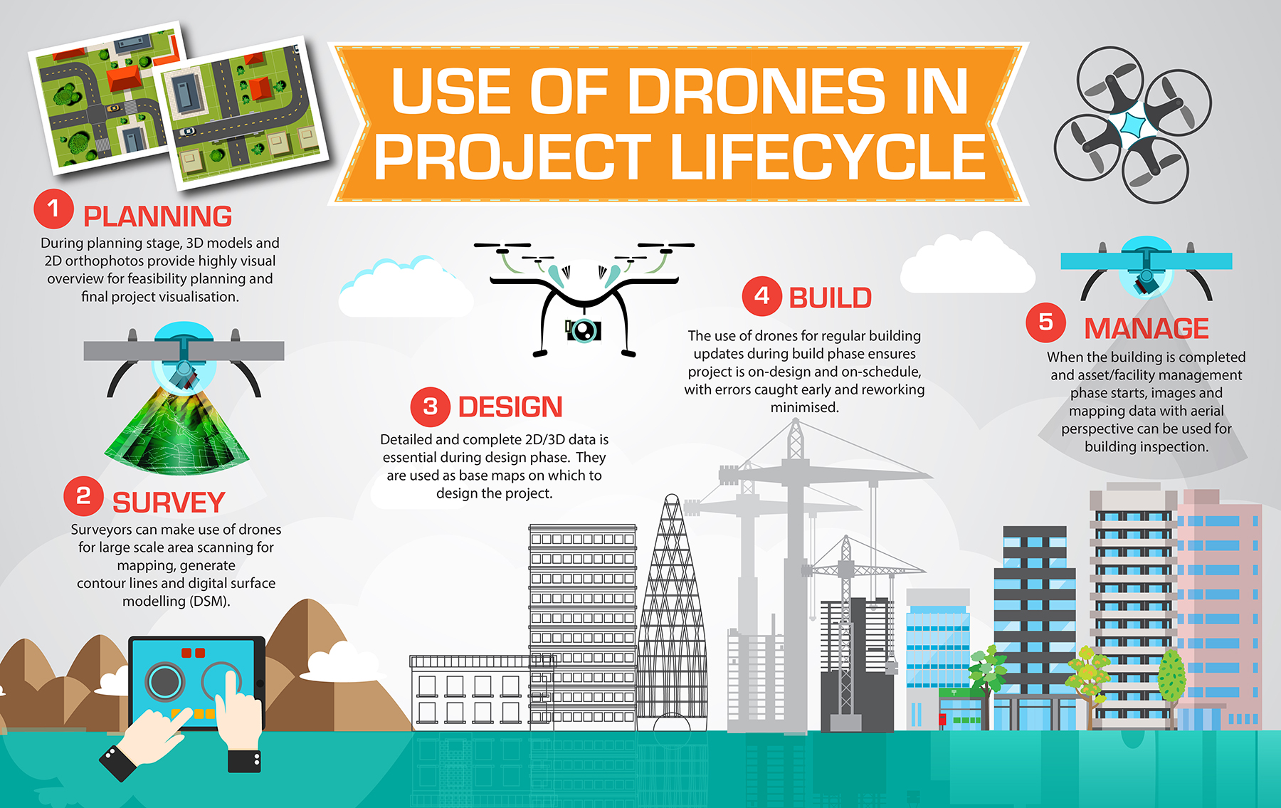
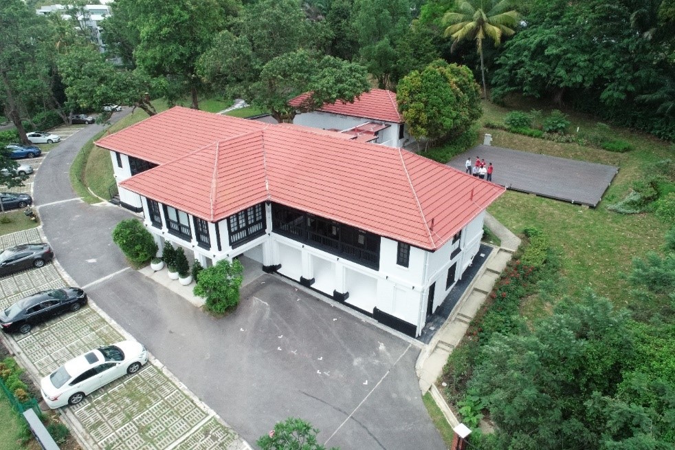
Illustration B: Remote monitoring and inspection of SJ Gobal Academy @ 7 Adam Park using Drones

More crucially, SJ uses Building Information Modelling (BIM) to manage design and engineering information for projects across the project lifecycle. A key output is the digital modelling and description of every aspect of the building or infrastructure asset, drawing on information assembled collaboratively and updated regularly. Additionally, putting BIM on the Cloud (Refer to Illustration C) allows project information to be accessed by the appropriate people when required. Complex designs can be created, discussed, revised and updated with ease from any location.

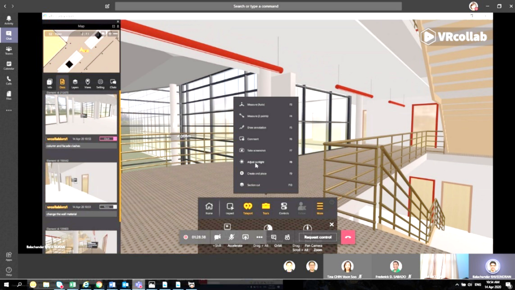
Illustration C: Design and construction can be done virtually and remotely using BIM on the Cloud

By combining people, process and technology, these advanced tools help companies in the built environment create value under normal conditions. In crisis situations, their value is amplified. They enable teams to make informed decisions and continue driving the best outcomes for clients.

Companies in the built environment will no doubt continue to face disruptions caused by the COVID-19 outbreak, but those who have invested in digital technology to support collaborative ways of working will likely be in a stronger position to carry out their operations seamlessly. For them, COVID-19 could well stand for “Construction Overcoming Virus Using Digital solutions”.

** End **

Connect with Us

Eugene Seah
Email: eugene.seah@surbanajurong.com


BIM Me One More Time

In the beginning of 2019, the Robert Bird Group (RBG) embarked on an ambitious journey within our Engineering and Technology (E&T) Platform. The aim was to increase the uptake of engineering and technological initiatives and upskill our staff within the confines of our core business, which is engineering. Building Information Modelling (BIM) as part of E&T was nurtured, but it was mostly only known to industry leaders.

Within the BIM circle, I was recently referred to as the visualisation guy twice in a span of two days when trying to address specific BIM-related queries. In reality, I am one of the visualisation guys but at that particular moment, I was acting as a BIM technical support staff. In a way, that reference is a curious by-product of the current state of industry we are in – equipped with little or no understanding on the terminology of BIM. It also reminded me of a conversation I had several years ago when I was asked if I could ‘do’ BIM, or in other words if it was something doable? These questions on BIM prompted me to at least try and settle the burning question – what the heck is BIM anyway?

 CAD and Its Early Days

Computer Aided-Design or CAD has been around since the 1960s with the progression of manual drafting to the utilisation of CAD as a drafting tool. The benefits of CAD and the ability to perform engineering analyses, without a doubt, had the biggest impact on the architecture, engineering and the construction industry.

CAD was revolutionary. It gave designers a new dynamic of robust and fluid software to produce drawings and perform complex analyses on projects which became increasingly multi-faceted. It was also extremely easy to understand and define.

Then along came BIM, and with-it confusion. Is it CAD? Is it more than CAD? How can something be more than CAD, seeing that it is also computer-based and similarly producing engineering analyses with drafting capabilities?

BIM quickly became the buzz word and for the first 10 years it was known, hardly applied but always discussed within the industry. BIM became the cool uncle.

Needless to say, reality sets in. It was not the elixir which everyone expected. The transition from CAD to BIM became a concern financially, and the return of investment matrix did not seem to add up and skilled resources were few and far between. Naysayers sat on the fence, the believers soldiered on.

Gradually, the investment on BIM did pay off and everything made more sense. The excitement returned and for a while, it looked like BIM was finally working, albeit on a concentrated level. Meanwhile the understanding of BIM stagnated, but the project procurement wheel kept on spinning.

Something was still amiss. A glitch in the Matrix, maybe? The question of ‘Do we do BIM?’ was still bothering me.

It made me think about my reference as the visualisation guy, and realised that the lay person might not necessary understand BIM. I need to do better in explaining BIM, and to do so, it requires a re-evaluation of my understanding of BIM. I realised I was trapped in Hodor’s Bootstrap Paradox – the infinite cause-effect loop.

So, What Actually is BIM?

I have encountered various definitions from, “it is a concept of working collaboratively”, to “it is not a software but a process”.

One of the main misunderstandings is that BIM relates to buildings. The word “building” from BIM is a verb. It is an all-encompassing undertaking to build an information rich computer model which becomes the digital twin of the actual infrastructure. Putting this simply – CAD on steroids.

To achieve this requires a complex and intertwined concoction of processes, workflows, software, hardware and skills. It is not achieved by a single individual but rather as a collective endeavour.

Think about BIM as a collapsed star spewing information and data with CAD at its core. It utilises the four stages of development and is in constant and perpetual motion – Synchronicity – Process – Application – Mining. I know, it is spelled SPAM. This means BIM is SPAM…in a funny way.

Figure 1 – BIM Genesis Wheel (image by F.Kumthanom)

Synchronicity

BIM begins with the utilisation of computer aided-software to create one or multiple 3-dimensional computer model. This assortment of software requires interoperability capabilities to enable a collaborative and synchronised working environment. It also entails coordinated information flowing from one software vessel to another, and concurrently retaining its 3-dimensional geometry. With the 3-dimensional model(s) created, BIM requires a process to guide design consultants throughout the project stages.

Process

The processes usually include submissions of partially constructed 3-dimensional computer model(s), quality control and review, engineering and sustainability analyses, etc. These are one of the many processes required during the lifecycle of the project. The 3Ws tool (Who’s Doing What & Where) is used to identify these processes and provide a practical component of information management, project coordination and gap analysis assessment. It demonstrates how workflow is constructed, how data is stored and how the associated model elements are checked and used.  Subsequently BIM is then applied to harness this data information.

Application

Through the application of BIM, we understand the challenges prior to construction, and also predict the time required for a facility to complete. We can accurately estimate the cost and know how much material is required for a facility. Building contractors mine and utilise these data for a variety of reasons – ranging from fast-tracking of projects to pre-empting of construction issues.

Mining

Mining BIM data provides immediate information ranging from cost comparison, understanding of project programme, managing building code compliance, constructability, risk mitigation and much more. Nevertheless, the GIGO (Garbage-In-Garbage-Out) principle still applies to BIM and therein lies the fundamental principles of BIM which are attention, commitment and consistency. These three principles are crucial for the success of producing a BIM 3-dimensional model and with it an Information model.

In conclusion, this is also my call to arms for BIM. BIM is ever-changing and ever-evolving. As the Internet of Things encroaches this space, BIM itself will morph from being a CAD on Steroids to becoming an integral part of machine learning through Artificial Intelligence. It is the future and it is now.

Revisiting the question of do we ‘do’ BIM?

My answer to that is: “More than ever.”

** End**

Connect with Us

Ken Lee

Email: Ken.Lee@robertbird.com.au


Perspectives, developed by SJ Academy, is our platform to explore new ways of tackling some of today’s most complex challenges. We draw on ideas and opinions from our staff associates and experts across different businesses. Click here to read more about the Workplace of the Future, Singapore’s Logistics, and Aviation Planning in Singapore.

Flooding: How Can Cities Be Prepared for an Increasingly Unpredictable Future?

2018 was a year of unprecedented global weather events. In Asia, Super Typhoon Mangkhut brought close to $50 billion in damages to Hong Kong and China, on top of $16 to $20 billion it exacted from the Philippines (Yap et al., 2018), while extreme precipitation-induced flooding in Kerala state killed at least 350 people and displaced over 800,000 (Kotecki, P., 2018). Meanwhile, 2019 started off with a historic deep freeze in the United States, brought about by unusual polar vortex formation (Channel News Asia, 2019).

Causes of climate change has long been associated with extreme events and is the biggest threat to the planet as reported by the World Economic Forum. Unless drastic changes are made to prevent global temperatures from rising more than 1.5 degrees Celsius, it is likely that we will continue to witness such events with increased magnitude and frequency. These events will continue to interact with complex systems, eventually set off their own ripple effects in a cascading manner akin to toppling dominoes (U.S. Global Change Research Program, 2018).

Introducing Resiliency in Global Warming

In the face of global climate change and diminishing natural resources, designing today’s cities and buildings require environmental, economic, and social considerations. The Rio Earth Summit in 1992 saw Sustainability at the forefront of many global policies aiming to minimize impacts on the environment. While Sustainability focuses on how we can slow down effects of global warming to the Earth, there is also a pressing need to look into the aftermath of warming – that has long been associated with extreme weather events. This is where we enter a new field known as “Resiliency”.

Importance of Resiliency Planning

For the past 20 years, climate-related calamities accounted for 91% of all disasters, with floods topping the list at 43%. Direct economic losses within this period due to climate-related and flooding specific disasters brought about US$2,245 billion and US$656 billion worth of damage respectively (Crunch, C., 2018).  In terms of property value, a study by First Street Foundation (2019) has found that property values on the East and Gulf coasts of United States have reduced by $16 billion due to flooding threats, signalling that the market is already reacting to such disasters. Recent research in the field of attribution studies has further demonstrated that the frequency, intensity, and duration of natural disasters will continue to increase due to climate change (Achakulwisut, P., 2019).

And how do all these impact our lives and homes? How will our cities deal with such uncertainties of the future? Are we doing enough to overcome the challenges that lie ahead while mitigating risks? – The field of “Resiliency” attempts to shed light on planning ahead for such possible uncertainties of the future. From a broader perspective, resiliency is defined by the capacity of individuals, communities, institutions, businesses, and systems within a city to survive, adapt, and grow regardless of the kinds of chronic stresses and acute shocks they experience (100 Resilient Cities, 2019). From a flooding perspective, it is about how cities can plan for a flood-resilient future.

In light of recent severe events, and the risk of them occurring again, it is appropriate to consider how to assess flood risks in order to reduce the likelihood of flooding, and robust planning for a flood-resilient future. Such an approach usually considers the 4-R model developed by the Multidisciplinary Center for Earthquake Engineering Research (MCEER) at the University of Buffalo in the United States, which describes resilient systems as one that encompasses the following properties:

  1. Robustness (ability to withstand shocks, such as housing and bridges built to withstand flood waters)
  2. Redundancy (functional diversity, such as multiple evacuation routes)
  3. Resourcefulness (ability to mobilize when threatened, such as functional community groups who can quickly turn a community centre into a flood shelter), and
  4. Rapidity (ability to contain losses and recover in a timely manner, such as access to quick finance for recovery)

Digitisation Enables Us to Predict Flood Risks Unlike Before

The World Economic Forum 2019 in Davos with Industrialization 4.0 taking centre stage focused on digitisation, which enabled the interaction of multiple layers of data to generate insights and predictions unlike before. Such approach towards flood resiliency will transcend current approaches, which are currently conducted in a siloed, non-repeatable, and non-integrated fashion, as well as address currently missing key considerations, from specific geographies to the timing of storms that introduces complex compound flooding (Begos, K., 2019).

Our approach leverages on a common Geographic Information System (GIS) platform that brings together a multitude of data accurately geo-referenced to a single point, providing the basis that makes interaction possible. Among the comprehensive list of data required (refer to Illustration A) for such an analysis are the topographical survey, building models, local rainfall, waterbody distribution, drainage network, and imperviousness data, that are most crucial for an accurate assessment.

Learning from Nature to Effectively Mitigate Flood Risks

While embarking on digitisation endeavours and relooking at traditional approaches, we should not neglect processes that have worked brilliantly for billions of years – that is nature. By safeguarding natural buffers, we can leverage them to enhance protective functions and confer disaster resilience. This is in line with the United Nations Disaster Resilience Scorecard for Cities (2017), as well as the Sendai Framework for resilient cities.

Since the last century, urban planning was focused on adopting a “pave, pipe and pump” methodology of stormwater management (Knight, S., 2017), discharging them into sewers as soon as they make landfall. Recent unprecedented flooding events across the globe with effects intensified by both climate change and urbanisation have demonstrated that such an approach is no longer relevant. A softer approach should be taken, as opposed to solely upsizing and re-laying concrete pipes and sewers for every new flooding hotspot that occur (refer to Illustration B).

Termed as low impact development (LID), these flood mitigation measures mimic natural processes using solutions such as vegetated swales, rain gardens, wetlands, etc to absorb, infiltrate, diffuse and convey stormwater runoff. Apart from reducing the peak flow rate of runoffs, they also improve water quality and enhance overall biodiversity and aesthetics of its site. Such projects have been gaining traction across major cities in United States, China, Australia, and Singapore, seamlessly integrating LID with architectural and landscaping elements to create biophilic “Sponge City” environments (refer to Illustration C).

The Next Frontier in Flood Resiliency Analysis

Given the high natural variability and underlying dynamics of climate, it is extremely challenging to model and predict flood risks. As such, before we can even consider flood mitigating solutions, it is imperative to consider how to precisely target existing and future flooding hotspots, evaluate the effectiveness of deploying a single or multiple arrays of solutions and quantify the before and after flooding risks to arrive at a practical solution. On top of quantifying flooding risks and evaluating suitable mitigating strategies, digitisation enables us to visualise flood water propagation throughout every stage to facilitate informed decision making.

Our flood risk analysis is applicable for projects ranging from small-scale plot level developments to mid-scale district zones, and large scale urban planning projects – providing tailor-made flood resilient solutions for every client. A combination of resultant flooding hotspots, water depth indication, and animation of flood water propagation interacting with topography and physical obstructions provide for multiple angles of analysis.

When capacities of storm sewers, drains, and rivers are exceeded during a precipitation event, stormwater runoff will start propagating to low lying areas that can be visualised in a flood propagation animation that varies with time. Together with a flood risk map, this enables planners to precisely determine which zones are at risk, evaluate a combination of suitable mitigating solutions or re-locate critical zones to less flood-prone areas, effectively taking the guesswork out of their design. A demonstration can be seen in the figures below, showcasing “before” and “after” flooding risks. Such optimization can potentially save the many lives that have been lost in recent extreme precipitation events by putting effective measures in place beforehand. After all, investing in pre-event resilience building is more cost-effective than simply cleaning up after a disaster.

Illustration C: The City’s Flood Risks from a 1 in 50 Years Precipitation Event, Before and After Incorporating Mitigating Solutions such as LID and enlarged drainage pipe sizes. Multi-Coloured Spots Outlined in White (with the legend on the right) Demarcates Depth of Water Ponding. (Regions circled in RED indicates potential flooding hotspots on land. Regions circled in WHITE indicates the problem of flooding has been reduced/resolved.)

Flood propagation animation for an existing flood-prone district in Vietnam, showing how flood waters from an extreme precipitation event interact with site topography and buildings to propagate throughout the site. Red-coloured outlines demarcate the site boundary, while brown-coloured blocks represent buildings.

Our Smart Approach Towards Flooding

During actual deployment, real or near real-time sensors can be considered in conjunction with weather cameras to provide data to monitor flooding situations. Such data is first input to a sensor fusion platform which is then fed into our model, after which the output is visualized in the city or estate operations control centre for the controller to activate or even automatically trigger certain emergency processes such as evacuation, road closure or traffic diversion. Nearby safe shelters or medical facilities locations and information can be communicated to the public via mobile applications or roadside display panels.

Furthermore, the flooding analysis model can also be integrated into a digital twin of the physical environment to allow other systems to be built on it, interacted and tested to a certain confidence level before rolling out to the actual environment. This helps to continuously train and update the model with real-time information to make it more intelligent and robust for detection and triggering of future events. The flood analysis model can help to fine tune the placement of sensors through testing in the digital twin environment to increase the availability or accuracy of data or even better communicate to the public in the event of an emergency. Through this exercise, it helps the city or development agencies better plan and manages an emergency event from the input of data, triggering of actions and communication to the public. Ultimately, calibrated digital twin enables for far more effective real-time operational decision making and control, that also facilitates risk prediction and defining the best course of action to prevent communities from being taken by surprise (Begos, K., 2019).

Conclusion

Moving forward to a future with an increasingly uncertain climate, there needs to be a paradigm shift in the way cities are planned and designed, using such flooding analysis to provide certainty for our future cities to become flood resilient, and smart tools to provide real-time information to facilitate decision making. In doing so, we are not only building cities but also shaping the lives of those people who live in them.

REFERENCES:

100 Resilient Cities (2019). Defining Urban Resilience. Retrieved from: https://www.100resilientcities.org/

Achakulwisut, P., (2019). Climate Change is a Public health Emergency. Scientific American. Retrieved from: https://www-nature-com.proxygw.wrlc.org/articles/s41558-018-0315-6

Begos, K., (2019) Local Flood Forecasting Has Been Dangerously Imprecise – That’s About to Change. Scientific America. Retrieved from: https://www.scientificamerican.com/article/local-flood-forecasting-has-been-dangerously-imprecise-mdash-thats-about-to-change1/

Channel News Asia (2019). More than 20 dead in US polar vortex, frostbite amputations feared.

Retrieved from: https://www.channelnewsasia.com/news/world/more-than-20-dead-in-us-polar-vortex-frostbite-amputations-11194248

Crunch, C., (2018). Economic Losses, Poverty & Disasters 1998 – 2017. US Agency for International Development

Disaster Resilience Scorecard for Cities (2017). United Nations Office for Disaster Risk Reduction.

First Street Foundation (2019). Rising Seas Soaked Home Owners for $16 Billion Over 12 Years. Scientific American. Retrieved from: https://www.scientificamerican.com/article/rising-seas-soaked-home-owners-for-16-billion-over-12-years/

Knight, S., (2017) What would an entirely flood-proof city look like? Retrieved from: https://www.theguardian.com/cities/2017/sep/25/what-flood-proof-city-china-dhaka-houston

Kotecki, P., (2018). Natural disasters set records around the world in 2018. These were some of the worst. Business Insider.

Retrieved from: https://www.businessinsider.sg/worst-natural-disasters-records-world-in-2018-2018-11/?r=US&IR=T

List of Data Required for Our Flood Analysis Includes:

Aquifers, building models, climate, discharge locations, drainage network, flow diversions, imperviousness data, land use, LID design parameters, local rainfall, manhole design, orifices, outfall locations, pumps, river flow centrelines, storm water storage tanks, subcatchments, topographical survey, waterbody distribution, and weirs.

U.S. Global Change Research Program (2018). Fourth National Climate Assessment. Retrieved from: https://nca2018.globalchange.gov/

Yap et al., (2018). Hong Kong On Lockdown as Typhoon Mangkhut Arrives. Bloomberg.

Retrieved from: https://www.bloomberg.com/news/articles/2018-09-14/super-typhoon-mangkhut-slams-philippines-with-category-5-power

Special thanks to Eugene Seah (Acting Head, Sustainability & Resiliency Office) who has sponsored the article, and to the following for their contributions:

Adam Kua ZhengJie
Engineer
Sustainability and Resiliency Office

Yi Huilin
Engineer
Sustainability and Resiliency Office

Martin Lim Huat
Principle Project Manager
Sustainability and Resiliency Office

Perspectives, developed by SJ Academy, is our platform to explore new ways of tackling some of today’s most complex challenges. We draw on ideas and opinions from our staff associates and experts across different businesses. Click here to read more about the Workplace of the Future, Urban Development, and Water Management.

Flowing Towards a Sustainable and Resilient Infrastructural Future

Returning from London in October 2018 as the sole winner of the United Nations’ (UN) World Federation of Engineering Organizations (WFEO) Young Engineers competition, I found it to be somewhat a déjà vu experience.

Back in 2015, I went to California, proudly flying the Singapore flag, to receive my American Water Works Association’s PhD prize – the first ever award for a doctoral dissertation outside of North America since 1966. I was reminded of how Singapore, a nation scarce in natural resources and densely populated, could be so successful in rolling out its sustainability and environmental policies. In fact, the sustainability movement has evolved globally with most governments and private entities being acutely aware of environmental issues, and many viewing the environment as a strategic asset and a source of economic opportunity.

This is evident at the 24th Conference of the Parties to the United Nations Framework Convention on Climate Change (COP24) where conversations are around limiting global warming. Many on ground observations have already outpaced what the modelling and simulations have been warning us about, and it is timely to consider climate change adaptation more seriously than mitigation.

The philanthropic project which I led for the Hlaing Thar Yar township in Myanmar when I was the Deputy Director for Nanyang Environment & Water Research Institute Community Development (NEWRIComm) at Nanyang Technological University (NTU) illustrated the intricate complexity of our environment, and the importance of social and economic consideration, in providing safe water to an under-served community. Striking a balance is key to the success of the project with coordinated planning and execution.

Case Study: Woes of the HIaing Thar Yar Community

Hlaing Thar Yar is a large industrial city in the Yangon region. A severe Cyclonic Storm Nargis hit the city in early May 2008, which caused the worst natural disaster ever recorded in the history of Myanmar.

Following the disaster, the community was forced to live in slum-like conditions. The city was ill-equipped with proper waste and water management systems. The community did not have access to clean water due to the polluted brackish underground water in the area. As a result, it had to purchase portable water for their daily needs. The Don Bosco School in HIaing Thar Yar which serves 350 children and parishioners through school programmes and religious activities was in dire need of access to clean water.

Water Management: Making Every Drop Count

The only water source within reasonable proximity from the school’s compound is its polluted saline ground water. To provide a proper water management system, we proposed a Reverse Osmosis (RO) treatment system (please refer to Illustration 1) designed to produce 5-10 cubic metres of drinking water daily[1]. To ensure that the system is protected from natural elements like soil conditions, supporting civil and structural components were designed in-house for quality assurance and cost effectiveness.

It is known in the industry that the utilisation of an RO system is energy intensive and expensive, and may not be suitable for community development projects. This is compounded by the extensive pre-treatment required which results in higher operational costs.

[1] System is designed at 1m3/h average production with double capacity at maximum. 1500 pax @ 10m3/day = 6.8L/pax/day for only essential drinking and cooking according to WHO guidelines that requires minimum 5.5L/pax/day.


Illustration 1: Reverse Osmosis (RO) Treatment System (Photo credit: Nanyang Environment & Water Research Institute)

Hence, a sustainable model was formulated to ensure that the resources required for water production is sufficient for the community to operate and maintain. Affordability in the production of water remained key for this project.

The engagement with local authorities, village head, the school and community resulted in a positive and meaningful outcome. The school was subsequently appointed as the overall-in-charge to manage the operations and maintenance of the RO treatment system.

Well-oiled Machine & Community

Designed with the community in mind, the project which was funded by the Lien Foundation, utilises proven technology to achieve the most economical and sustainable solution for water management & treatment. Critical instrumentation like pressure transmitter, conductivity meter and oxidation-reduction potential are placed at various process stages for continuous monitoring. These stages are conscientiously selected for the project for their simplicity, ease of maintenance and ability to support the concept of affordability at its core.

To do this, we had to understand intrinsically the process and importance of control and automation. The most common cost of failure in an RO system is the ineffective pre-treatment process. This often results in poor reliability of the system, degrading life span of membrane and high operating cost. Overdosing of coagulants and overfeeding of chlorination will also cause common failures which affect the RO system. To prevent such problems, process instrumentations are used to monitor critical parameters such as differential pressure, conductivity, oxidation, and early warning signs of pre-treatment failure.

Another main concern in today’s conventional water treatment control system is that they lack the ability to communicate all processes monitoring from a centralised location, especially at remote location(s). Also, this complex control system requires skilled operators to monitor and control the process operation. In the case of Don Bosco School, the locals are not trained in this field. And to resolve these issues, an IoT (Internet of Things) protocol was introduced to allow remote monitoring of the process.

Going by Gold Standards

The International Finance Corporation (IFC) Performance Standards is widely accepted as a global standard to ensure projects are developed in a sustainable fashion – conserving natural resources, protecting people’s livelihoods and promoting project benefits. The Performance Standards provide guidance on how we can identify and manage risks and impacts, as well as outlining requirements for stakeholders’ engagement and disclosure obligations. In addition, projects must also conform to in-country regulations and international obligations.

Through funding from the Lien Foundation, NEWRIComm has embraced the IFC concept which exhibited the essence of sustainability in evaluating the project, ie assessment with the community in mind. This is essentially what global international financing and aid funding organisations, including the World Bank, Asian Development Bank, African Development Bank, AusAid, US Millennium Challenge encompass. It is important that social and environmental sustainability hold equal weightage in delivering a sustainable and resilient infrastructure to alleviate poverty.

Conclusion

The Hlaing Thar Yar township project, administered by NEWRIComm and funded by Lien Foundation, provides for the improved development of the community. I quote from Chairman of Surbana Jurong and Changi Airport Group, Mr Liew Mun Leong’s book, entitled: Sunday Emails from a Chairman (Volume 5, 20th Anniversary Edition, Page 91), “Economic studies have proven that a development strategy based on sustained, large-scale investments in strategic infrastructure projects can contribute significantly to a country’s economic growth”. I resonate strongly with Chairman’s sharing. We need to be conscientious that for infrastructure to be sustainable, it needs to gain wide acceptance by the community-at-large, which paves way in exhibiting its full value to support inclusive human development. Failure to do so will only result in a building or structure with no purpose or a state of derelict, i.e. the common notion of a white elephant.

While emphasis on the project’s technical soundness and economic viability should not be over stressed, it needs to be guided by a few attributes during its conception stage to achieve its eventual value. I am inspired by the five virtues of Confucius:

Ren (仁); Kindness & Empathy (Meeting Needs)

  • This infrastructure is meant to serve the people. Any infrastructure will need to be designed with end-users in mind, so it will be taken care of like its own.

Yi (义); Fairness (Win-Win)

  • The financier, consultants, developers, and owners have profits to make, which sometimes result in the community being forgotten and forsaken. Without the inclusion of community, it is only a short-term gain without an equitable long-term framework for a sustainable and continuous development.

Zhi (智); Wisdom (Innovation)

  • Take more calculated risks. We need to innovate continuously, and not rely on others to do the work for us.

Xin (信); Trust (Collaboration)

  • Tap on one another’s network and expertise, to provide quality proposals and deliver projects on time and on budget.

Li (礼); Respect (Joint Ventures)

  • While we may be superior in terms of techniques and knowledge, we need to remember that we must never take this as an entitlement. Every country has its own rules and culture, local knowledge is more important than what the best technology can bring.

About Nanyang Environment & Water Research Institute (NEWRI)

NEWRI is part of the Nanyang Technological University, Singapore and is globally ranked amongst the top research organisations in the environment & water domain. NEWRIComm has been conferred multiple accolades, including the NTU Humanitarian Award 2018, and both ASEAN Outstanding Engineering Achievement Award and IES Prestigious Engineering Award in 2017 – for its novel and innovative solution in a community development project in Sri Lanka.

[1] System is designed at 1m3/h average production with double capacity at maximum. 1500 pax @ 10m3/day = 6.8L/pax/day for only essential drinking and cooking according to WHO guidelines that requires minimum 5.5L/pax/day.

Perspectives, developed by SJ Academy, is our platform to explore new ways of tackling some of today’s most complex challenges. We draw on ideas and opinions from our staff associates and experts across different businesses. Click here to read more about the Workplace of the Future, Urban Development, and Water Management.

Powering the Water Sector Using Smart Technology

Flowing and Taking Form, Digitally

Universally, the Water Sector has embarked on a journey towards digital transformation, in tandem with the technology shifts happening in other infrastructure industries. Smart technology has crept into our lives, in ways we do our work as designers, and how various infrastructure owners operate and maintain their assets.

It is an exciting time for our industry, and it is interesting figuring out which side of the fence we are sitting on. We need to ask ourselves; do we want to miss the opportunities presented by new technologies, or do we want to be an early adopter?

The key to success is being aware, adaptable and be ready to take on change.

Not only must we be open to the digital innovation wave that is presented to us, we must also be ready to select the technologies we want to champion and apply early. In doing so, our clients can capitalise on these advances.

A large part of SMEC’s business derive from setting foot in the early adopters’ camp. We take on proven technologies and processes as they become available to us, and partner with companies to drive new opportunities. Some of the real value is making technologies available, and tailoring them to our clients’ specific needs.

Novel Ways to Capture and Interpret Data

Remote data capture is already embedded within the engineering community across the board and particularly within the hydropower, dams and water sector.

We move across various spectrums of technology – from aerial photography, to drones, LIDAR, 3D scanning and multiple forms of remote capture that acquire a broad data scope. The team focuses on cross-examining the data, and importantly, aims to capitalise the depth and richness of the data in different ways. A great example of this is how we manage both the collection and interpretation of data from drones.

While we are accustomed to using drones for project images and videos, our requirements have also advanced at a rapid pace.  Often, there is significant cost and time involved, and limitations on how much data a person can collect within a certain amount of time. Now we are starting to use drones in confined spaces, inside a reservoir, pipeline, manholes, pits and places which potentially pose danger to people.

The role of the engineer has also shifted in how he uses technology in a much more interactive and effective way, to increase the quality of data captured – including real time capabilities.

Back in the office, we use smart automation to connect multiple data sources and analyse the results. The data interpretation is complex and operators still require a solid technical background to understand how to analyse the data.

Driving Innovation Through BIG Data Analytics

It is possible to capture large data sets from clients over several years of asset monitoring. We utilise unguided analytics – find patterns in the data without any technical preconceptions – to extract valuable insights, and then leverage on our technical experience to understand and apply those patterns.

This is a process which has been applied recently with Queensland Urban Utilities (QUU), one of the largest water distributor-retailers in Australia – supplying drinking water, recycled water and sewerage services to a population of more than 1.4 million in South East Queensland. The SMEC team did some unguided analytics on the work order history of sewage pump station assets (such as requests for repairs, replacement and other works) as part of the “Enhanced Condition Assessment Programme”. The analytic plots revealed patterns and trends in the dataset which allowed QUU to make informed decisions on how to prioritise their maintenance efforts, future budgets and reduce the operational risk of assets (i.e. assets which are causing the most outages/disruptions, and then targeting them for future maintenance strategies). We were able to pull trends from the data results and confidently engage QUU with data driven recommendations to improve maintenance operations across their asset portfolio.

Championing VR/AR

The SMEC team also recently completed a 3D scanning project in the galleries of a wastewater treatment plant for South Australia Water. This project involved areas which were difficult to access by conventional means. The team produced a 3D model of the galleries which was used as an important resource for the design of key remediation works.

In addition to producing the 3D design, SMEC has championed virtual and augmented reality (VR/AR) in the built environment. Other civil engineering and water infrastructure projects include the iconic Snowy 2.0 project, a proposed pumped-hydro expansion of the Snowy Mountains (New South Wales) Scheme which will supercharge its existing hydro-electric generation and large-scale storage capabilities. Here, we utilised VR construction visualisation. Additionally, we have transformed the design into an animated construction sequence where we can see how the project will actually be constructed.

Technology’s Role in Water Security

A recent online article in Create magazine (https://www.createdigital.org.au/magazines/australias-water-security-issues-engineering/) written by my SMEC colleague, Jonathan Kent, outlines how Australia is increasingly adopting dams and engineered water storage. He described how other more high-tech and expensive technologies such as desalination have been installed to provide increased water security to major urban areas. I agree that providing water security to the driest and most in-need areas is the most challenging issue to overcome, especially when urbanisation of major coastal centres continues.

The SMEC team is providing expertise to address the issue, and we are working with Water New South Wales (NSW) on the implementation of the Wentworth to Broken Hill Water Supply Project, which will provide greater water security to regional NSW.

Leading Innovation Across Other Areas of Specialties

To keep up with challenging external environments, our clients and partners are increasingly placing high values on innovation. SMEC has entrenched this culture of innovation with an Innovation Grants Programme, which provides employees an opportunity to pitch and refine their ideas for innovation, and a chance to secure funding to develop their ideas.

Our commitment to smart technologies within the water sector aligns with our broader interest in renewables and sustainability. Our designs positively impact the built environment and help to shape a better future for all.

SMEC was also the Design Lead on the Sydney Metro Northwest surface and viaduct civil works (SMNW-SVC) project, which has been consistently recognised for innovation and sustainability. In 2015, the project won a Leading Design IS rating from the Infrastructure Sustainability Council of Australia for the most environment-friendly project design. In 2017, the project was recognised as a “Leading” As-Built IS rating – the highest possible score for sustainability. And in 2018, the project clinched “Project of the Year” and “Global Best Rail Project” from Engineering News-Record (ENR), which described its design as ‘elegant, innovative and sustainable’.

This article was first published in Infocus, SMEC’s digital platform (http://www.smec.com/infocus/expertise/powering-the-water-sector-using-smart-technology/)

Perspectives, developed by SJ Academy, is our platform to explore new ways of tackling some of today’s most complex challenges. We draw on ideas and opinions from our staff associates and experts across different businesses. Click here to read more about Aviation Planning in Singapore, Infrastructure & Connectivity, and Facilities Management.

Drones at Work – Eyes in the Sky!

Introduction

Drones are now one of several technologies that are transforming every stage of the engineering and construction process. Its use does not only constitute to productivity boost, but every advancement in drone technology provides for better airspace awareness, transformative designs and more intelligent piloting modes.

Surbana Jurong (SJ) is no stranger to drones which have many uses, from conducting inspections and surveillance, to security-led activities by AETOS (Member of the Surbana Jurong Group), and the Infrastructure team has been using drone inspection for land reclamation, and high precision data collection.

SJ has introduced drones in projects across the entire building lifecycle, from planning & design to construction & operations, to improve overall operational productivity and effectiveness.

As drone technologies (both hardware and software) become more developed, there is no doubt that drones help save time and hence, reduce overall costs substantially. Comparing with data collection from the ground; aerial techniques can provide more accurate site surveys, aerial data, photos, videos, thermal signatures, and other useful information in a fraction of the time.

Remote Sensing Made Easy

Traditional remote sensing studies require the academician to engage chartered manned aerial vehicle to capture dataset or make use of satellite imagery, followed by long man-hours to geo-tag, and lastly stitching of individual images to form an orthomosaic image.

Modern drones can now be equipped with payload [ie, the weight a drone or unmanned aerial vehicle (UAV) can carry] such as high-resolution cameras, geo-location sensors, infrared sensors, LiDAR, and can also be highly customisable depending on requirement of datasets. Together with refined photogrammetry software, millions of key points can be generated within a short span of hours with minimum human intervention.

So, How Do We Make Data Useful?

First, we make use of the contextual information which can now be imported into a survey software to create 3D models of existing conditions. These models will help in determining feasibility, understanding constructability, and help owners visualise what the project will look like upon completion. It can also be used to identify areas of risk.

Most work plans start with an accurate current topography map, with elevated contour lines and detailed 2D & 3D models for the Land Survey department, coupled with fill & earthwork hauling specifications for our Infrastructure department for rapid calculation. In this case, drones are used for surveys and inspections. And at a more progressive advanced stage, these activities will be enhanced with Artificial Intelligence, and further streamlined with Building Information Modelling (BIM) workflow.

A recent example of a drone job of this nature was when SMEC (Member of the Surbana Jurong Group) Dams Team travelled to the Eungella Hinterland in North Queensland to conduct a site recce as part of the Urannah Dam Feasibility Study. At the site, a drone was used to capture video footages, which were subsequently used by the project team to carry out their studies and video conversion. And still shots have been incorporated in relevant sections of the report.

From the end-user/client’s perspectives, drone surveys help inject real-world conditions into design and constructability conversations. The ability to easily capture site information improves the rate at which designs can be iterated on. Please refer to illustration 1 on how drones can be utilised during a design and build project lifecycle.

One simple method is to take an aerial shot of what potential tenants and investors would see when they look out from their office. This includes other visuals such as the reface views of the development, building models in the neighbourhood context, and even 180 or 360 degree visualisation from each floor.

Illustration 1: The use of drones during a design and build project lifecycle. Image credit: SJ Academy

Construction jobsite monitoring can use drones to capture pictures for daily, weekly, and monthly progress reports, or site survey maps that provide foundation for work plans. Drone images used in daily progress reports are great for change detection: they can help uncover issues that allow site managers to quickly resolve problems that can lead to performance delays.

Highly sensitive thermal camera can also be used as a payload in drone to assist facilities and security management teams in the creation of “live” data such as hotspot and water ingress behind façade.

And in the case of security management, AETOS uses drones for crowd surveillance and general security at major events. “AETOS has accumulated extensive experience in providing state-of-the-art UAV Services to the Singapore market, ranging from security surveillance and safety inspections to 3D modelling, photogrammetry and even land surveying”, shared by Robin Littau, Vice President (Business Development) of AETOS Holdings.

Robin continues, “Drones are able to complement traditional surveillance methods by covering larger areas, including blind spots while acting as a deterrent to illegal activities. Their versatility and reliability, as well as their potential to increase efficiency and productivity when used to aid ground operations, make UAVs a worthwhile investment for businesses in the security and safety industry”.   

Embracing the Technology; Small Step for Big Result

BIM offers cost and time savings, creates greater accuracy in estimation, and cuts down on errors, alterations, and rework due to information loss. To reap the benefits of BIM, everyone in the architecture, engineering, and construction industries will have to learn to work in fundamentally new ways.

As BIM-plus-drones is a whole new paradigm, taking small steps when implementing a BIM/drone data project is recommended. Choose the appropriate steps and tackle them one at a time. Do a test run on a pilot project, compare, and then use the pilot project to prepare for wider BIM/drone data implementation.

Conclusion

The key takeaway for drone technology is the ability to collect data, and to execute the same mission over and over without causing huge disruptions operationally. A long-term cost and manpower saving tool for the build sector, it has survived the test of time, and has proven to cut down human and technical errors. The drone technology has undergone many generations of technological advancements. And what’s left really is how much the value chain can take to its use, and embrace it in tandem with the digital age.

This article is co-created by Surbana Jurong Academy.

Perspectives, developed by SJ Academy, is our platform to explore new ways of tackling some of today’s most complex challenges. We draw on ideas and opinions from our staff associates and experts across different businesses. Click here to read more about Technology & Innovation, Infrastructure & Connectivity, and Design Leadership

Wanted: A New Paradigm for Construction

The Business of the Future

It’s an exciting time to be in the world. Humankind is dipping its toe into an expanding ocean of transformative technological innovation. The popular media is full of headlines claiming that technological innovations in medicine, transportation, finance, manufacturing and service industries are about to transform our lives. Social media is full of melodrama on Artificial Intelligence and how our world is about to change. Futurists like Gerd Leonhard warn us that we must embrace this challenge now, and not bury our heads in the sand or risk becoming a short biological prelude to a machine intelligence explosion.

But this article isn’t about predicting the future, it’s about looking hard enough and being brave enough to take action. We can all look back at predictions of the future made decades ago and laugh at their naivety, however any such disappointing points of reference simply divert attention from the fact that the accelerating rate of technological development will impact all our lives in the near future.

If you were working as a salesman in the automotive industry, a taxi driver, or even as an insurance or legal professional, would you have known 10 years ago that machine learning, coupled with advancements in scanning technology, would not only render drivers irrelevant but literally transform our paradigm for personal transportation? Probably not. In the coming years, a similar story will unfold in finance, law, service industries and many other professions.

Business leaders across the globe are now spending more and more time looking into the future. Artificial intelligence, additive manufacturing, nanotechnology and robotics are poised to penetrate and transform our industries, and business leaders want to be ahead of the curve. Futurism is now big business and business is taking it very seriously indeed.

Getting Left Behind

But what about the construction industry? Of all humankind’s industries, it is surely the most fundamental; fulfilling our basic physiological and safety needs described in Maslow’s Hierachy of Needs. Indeed, the Institution of Civil Engineers defines civil engineering in its Royal Charter as;

…the art of directing the great sources of power in Nature for the use and convenience of man…

Indeed, what other professions could claim such a grandiose role in society? Looking beyond the many great monuments across the world representing milestones in mankind’s historical ability to direct “the great sources of power in nature” such as the Pyramids of Giza, The Great Wall of China, The Empire State Building and the Panama Canal, the history of the built environment is littered with other lesser known but transformative technological milestones; Iron Bridge (1781, the first iron bridge), Ditherington Flax Mill (1796, the first iron framed building) and Alvord Lake Bridge (1889, the first reinforced concrete bridge) to name just a few.

The truth is these technological milestones have defined our paradigm for construction in the last few centuries. Our understanding of these traditional materials, and our ability to squeeze out ever increasing performance from them has continued to refine and improve the efficiency of the paradigm, but nevertheless the fundamental methods of construction, and the materials used to create our modern built environment, have remained exactly the same as they were.

Let’s take reinforced concrete for example. Ernest Ransome’s Alvord Bridge used deformed (twisted) reinforcement, placed by hand, and bonded to concrete poured into a shape predefined by temporary formwork. This process used in 1889 will seem familiar to many construction professionals today because it has fundamentally remained unchanged.

At this point I may hear protests from the industry, claiming a multitude of developments in the last few decades – concrete additive technology, prefabrication, modular construction, high strength steel and concrete to name a few. These are improvements sure enough, but they are no more than incremental changes, or slightly different applications of old technologies.

A similar story is apparent when we look at design. Computers have certainly improved our efficiency in performing calculations, and in some instances have helped us to perform calculations that were not possible before, however the fundamental paradigm for design remains largely unchanged.

Concept designs are based on the often tacit experience of individuals – feeding into a collaborative, iterative process to arise at a solution which is usually measured and compared using a combination of intuition and qualitative judgement. In general terms, as a project moves through the design stages the process becomes less creative, increasingly linear, more constrained by standards and more numerically driven. Despite the computing power that can be brought to bear using a standard desktop PC, the process remains relatively disjointed, slow and typically results in a compromised, imperfect outcome.

In terms of design communication, the use of Building Information Modelling (BIM) has improved our ability to visualise, measure and coordinate in three-dimensions, however the industry still insists, through fear and/or habit, on delivering 2D drawings – essentially the same format used to document designs several centuries ago.

There have been attempts in the construction industry to provide a vision of the future. A 2050 plan was recently announced by a major contractor which predicted the use of drones for surveying, Augmented Reality goggles for construction visualisation, exoskeletons for site workers and autonomous vehicles for delivery and movement of materials. When you consider that this represents a vision of construction in 33 years’ time (greater than the average age of many organisation’s employees), but is wholly based on current (or near-future) technology and relies entirely on current construction paradigms, it seems relatively short-sighted when compared with the blue-sky vision and ambition of other industries.

That’s not to say there aren’t innovation forums and platforms in the industry (i3P for example), all of which are welcomed, but I fear none really ask truly challenging questions of the industry or are brave enough to look far enough outside the box.

All of which reminds me of one of Henry Ford’s supposed quotations;

“If I had asked people what they wanted, they would have said faster horses”

Although it is quite possible he never actually said these words, they certainly ring true for the construction industry – replace the words ‘faster horses’ with ‘stronger concrete’, ‘better drawings’ or ‘more accurate surveys’ and you will see the parallels. The industry has spent the last couple of centuries trying to perfect faster horses.

So (staying with the equine analogies), while other industries have been seen accelerating technological change transform their horses into rocket-propelled drag bikes, the construction industry appears to be happy with its old lumbering nag, brushing its tail and giving it a pretty rosette from time to time when it learns a new trick.

Why is this? Where is the new paradigm for construction? What makes the construction industry different from other industries where innovation, forward thinking and technological advancements are embraced quickly with rapid rewards?

Industrial Lock-in

In Jaron Lanier’s book ‘You are not a Gadget’, he explains the concept of lock-in as it applies specifically to programming and the design of computational systems. The concept is that it can often be difficult to implement change, even when technology can provide a far better solution, simply because of the prevalence of the current system. The example Lanier gives is the use of the MIDI format in the digitisation of sound and music; a format that stubbornly persists despite its limitations. Indeed, Lanier states that lock-in hinders development and creativity as solutions are inevitably developed to work around the limitations rather than challenge them.

On this basis the construction industry has more lock-in than Alcatraz. Indeed it has more than any other industry I can certainly think of, and that includes the massive automotive industry. However, if size is not the key factor to lock-in then what is?

  • The construction industry builds unique products every time, differentiated either by brief, by design or by geographic/topographic constraints. As a result, the research phase of the product development cycle is non-existent and project teams are continually formed and disbanded without the benefit of continuity.
  • The design and delivery cycle of a construction project is typically divided by procurement models that aim to pass on risk and limit reward. It’s inherently an industry of self-interest. After all, who reaps the rewards for innovation and who carries the risks?
  • Economic drivers simply do not encourage innovation. How is anything different when there is no economic benefit to invest in change or do things differently? Why invest across boundaries when your commercial position is only as strong as your latest project?
  • Clients continue to equate value with lowest cost. Whilst there are notable exceptions to this, for many in the industry, it is extremely limiting when clients do not respect or value brands that represent quality in engineering. Whilst this can be seen in other industries, it would appear that these industries seem better at educating and influencing the market place. Why has the construction industry continually failed to educate clients away from a ‘lowest bidder wins’ mentality and towards one that values quality and innovation?
  • Standards and regulations always favour those that play safe and follow the status quo. They also vary by geographic location making it even more difficult to see the global picture when looking at the economics of innovation.

So there is lock-in on an industrial scale, the effects of which can be seen not just in an apparent lack of innovation but in stagnation of performance and a failure to meet society’s ever-increasing demands.

This is not new. Constraints to research and development in the construction industry have existed for decades and continue to hold the industry back. An example is the relatively recent application of additive manufacturing (3D printing) to the construction industry which, although holding great promise, has not yet been met with an adequate level of investment and interest by the industry;

  • 3D printing innovators are crying out for partners and investors to help them effectively penetrate the construction market.
  • Enthusiastic designers are wondering how they can apply the technology within current standards for competitive fees, or fit in a research project when they have ‘real’ projects to deliver.
  • Contractors are wondering how the technology adds value, whilst reducing cost and decreasing (or at least maintaining) levels of risk.
  • Clients just want their one-off asset at the cheapest price. Full stop.

While there is some innovative thought out there, the fact that the industry has failed to grasp the opportunities with both hands demonstrates a lack of holistic innovative thought and (cringe as I say it) an ‘out-of-the-box’ mindset. Why should it take a competition by NASA to get innovative thought moving in construction?

Similarly, in design delivery and design communication, advancements in technology have yet penetrated the industry. Issues of software compatibility, formats for data exchange, bandwidth for digital collaboration, digital change control, the application of machine learning algorithms, and the use of so-called ‘big data’ have yet to find their way to the construction market-place. The software part of the supply chain is too small to invest in the research and development necessary to apply these technologies effectively. And while the top-tier consultants inevitably use their own innovative abilities to apply patches to achieve certain aims (in the form of scripts and add-ins), the approach is parochial and the outcomes limited.

Design communication and coordination is perhaps an area where there is more of a buzz in the industry. Building Information Modelling (BIM) has gained momentum in the last decade, however this extended timeframe is symptomatic of an industry that is slow to realise the benefits of technology and stubbornly insists on keeping one foot in the past. Despite the obvious benefits in coordination, clash detection and design visualisation, one of the reasons 3D BIM was slow to penetrate the market was due to the criticism that it produced poorer quality drawings. We can all see the irony, but such lock-in is still pervasive today. 2D drawings are still a default contractual deliverable and are still the primary tool for design coordination and on-site reference. Faced with a problem, a site engineer is still likely to pull out a bulky roll of A1 drawings, thumb through them and scribble on them with a pencil – so clearly there is still much to be done to move an industry out of its comfort zone. With developments in virtual reality, and in particular augmented reality now providing tangible solutions, there is every reason to look at new paradigms for visualisation, communication and coordination that do not rely on rolls of paper, aid practical delivery and add significant value to project stakeholders. It’s not hard to see how powerful BIM could be when aligned fully with Life-cycle Asset Management and the Internet of Things.

To summarise, unlike a ‘widget’ market, where successful business models demand a more efficient widget, a different kind of widget, or even the benefits of a widget delivered in a different way, the construction market has no significant driver for change or innovation, or any effective mechanism to deliver it. The lock-in in construction is systematic and self-fulfilling. Faster horses it is then?

Time For a Change

The debate continues and the causes persist. But of course talk is easy and turning it into action is where it gets difficult. There’s clearly no magic bullet and making changes to an industry is akin to turning an oil-tanker locked on auto-pilot.

In very simple terms, the industry must turn its attention away from giving individual clients what they want and instead focus on developing new solutions for what society will need. The tail should stop wagging the dog. Clients will ultimately want what we can provide for society as it will make overriding commercial sense to provide it.

So how do we do it?…

  • More collaboration, less barriers. The construction industry is unmatched in its ability to collaborate on huge projects at very little notice, pulling together multi-disciplinary teams and extraordinary talent to solve problems. This collaboration needs to bridge across contractual, procurement and project barriers if long-term, value-adding, holistic solutions are to be realised. We need industry-led mechanisms to pull these barriers down.
  • More ambition. We need people to be ambitious and have strong and persuasive visions. Where are the industry visionaries sticking their heads up over the parapet? The industry needs to look beyond how it can utilise the innovations of other industries (although they inevitably have their place) and lead innovation from within – setting itself bigger goals. Institutions such as the Institution of Civil Engineers and the Institution of Structural Engineers are critical to engendering this ambition.
  • More learning from other industries. The construction industry will learn to innovate from within better if it looks outside itself. How do other industries do it? What barriers have they broken down? How do they work together? How do they fund research?
  • More original research. With greater collaboration and ambition, the industry will understand the research that it needs in both materials and construction methods, and the investment necessary to develop new holistic design solutions. As a regular reviewer of technical papers, I see very few that actually tread new ground or present innovative technologies or methods.
  • More understanding of the potential risks and opportunities technology presents to the industry. There is a general lack of understanding seen in other industries regarding the areas where technology will be pervasive and the consequences and strategies that go hand-in-hand with its use. The potential for automation, the application of machine learning and the future impact this will have on the design industry I will explore in a later article.

New paradigms for construction will only come from within the industry if the above challenges are met head on. So, while contemplating this challenge, it is worth remembering that the recent transformative developments in the automotive and personal telecommunication industries did not come from within those industries.

The world needs smarter construction solutions. I would like to think we are smart enough and determined enough to provide them from within the construction industry, but we must look to the future soon or someone, or who knows – maybe something, will take the future out of our hands.

This article is co-created by Surbana Jurong Academy.

Perspectives, developed by SJ Academy, is our platform to explore new ways of tackling some of today’s most complex challenges. We draw on ideas and opinions from our staff associates and experts across different businesses. Click here to read more about Technology & Innovation, Infrastructure & Connectivity, and Design Leadership

BIM for Facilities Management – Towards Digital Sustainability

Building Information Modelling (BIM) is a digital representation of physical and functional characteristics of a facility. It is about information that is built up starting from the phase of design, to construction, and finally operations and maintenance, in both geometry and non-geometrical form describing building elements. It is gaining traction around the world, presenting new ways of building models that were previously not possible. So, how can a BIM model be advantageous to facility managers?

It is important to firstly understand that BIM is not a technology. While technology helps in the creation of a BIM model, the software alone does not make up BIM. It is the way in which the model is produced, shared and used throughout the entire project life cycle. And in the case of Facilities Management (FM), it means working on the same vanguard beyond construction phase.

Where Model Integrates Data

Effective FM includes the ability to achieve real-time access to accurate information on building facilities. Knowing instantly about your assets (basic information) and how things can be fixed correctly (maintenance information) are key to providing quick & effective responses to issues & problems.

With BIM modelling that integrates real-time data, FM professionals are able to plan smartly for building systems that require preventive maintenance, and understand the real-time health conditions of the operations systems. For this, extending BIM modelling through to meet the needs of FM is essential.

Manufacturers are now offering their products in BIM format, so engineers and architects can incorporate specific product data into the model from the onset. One could even create a quick link of the manufacturer’s manual and operating instructions to our BIM FM models.

BIM Processes, Standards & Classifications

The BIM development process is usually planned and defined in the BIM Execution Plan (BEP), to ensure that all parties involved have access to shared data and platform. Data exchange formats need to be agreed by the entire value chain, collaborating and contributing to the Information Delivery Process.

A step-by-step approach (Refer to Diagram 1 – BIM Guide for Asset Information Delivery) is conducted to assist the building owner in:

  • Defining and identifying information requirements at Strategic Level (Organisational Information Requirements or OIR);
  • Achieving information requirements at Operational Level (Assets Information Requirements or AIR);
  • And how this could be specified in the Tender Specifications (Employer Information Requirements, EIR). our BIM FM models.
BIM Guide for Asset Information Delivery
Diagram 1: BIM Guide for Asset Information Delivery (AID), Source: BCA Singapore

The process also establishes an Asset Data Drop throughout the whole project cycle, adding data in the build-up of the BIM model. It is designed for BIM managers to manage all data drop during the design stage, and further complete it throughout the entire construction stage.

The current situation with the design and build sector is that asset information handovers are usually done in the form of 2D drawings or paper documents. Hence, COBie (Construction-Operations Building information exchange) standard is introduced as an open, standardised electronic format to replace the current paper-based documents. In general, the COBie standard was developed for the exchange of information including spaces, equipment and assets. This standard defines expectations for the exchange of information throughout the lifecycle of a facility.

The importance of building an Asset Classification Systems in BIM (Omniclass; Uniclass or other) is to provide the sector with agreed and standardised terminology and semantics. It is a unique set of numbers to describe everything in the building element, and is usually agreed upon at the planning & design stages. It also aids the contractor to ensure the completeness of this information in the handover BIM as-built model. The as-built model will then be made suitable for further development into BIM FM models, to be integrated for building facilities management.

BIM Maturity Towards Digital Sustainability

New projects are always planned with different set of requirements. Either the client or the local authorities have high expectations of the overall process of implementation regarding building standards and sustainable design. BIM allows all parties including building owners, architects, consultants, contractors and FM, to work simultaneously with the access of shared collaboration and BIM information.

In this section, we explore the different levels of shared collaboration and information throughout the lifecycle of a building asset and these are known as BIM maturity levels. As we move across the levels, the collaboration intensity increases. There are 0-4 distinct BIM maturity levels (please refer to Diagram 2):

Diagram 2: BIM Maturity Towards Digital Sustainability

Level 0 (Low Collaboration)

At Level 0, there is no collaboration between parties collating information about a built asset. Most data is available in 2D (likely CAD) drawings, and any exchange in information is done so using paperwork.

Level 1 (Partial Collaboration)

Most organisations today are conducting their work at this level. A Common Data Environment (CDE) is used in this case. It is an online shared repository, where all the necessary project data is collected and managed. BIM Level 1 focuses on the transition from CAD to 2D/3D pieces of information.

Level 2 (Full Collaboration)

At Level 2, collaboration is introduced between teams and the process of BIM is now being followed through. There is still a lack of a single source of data, but crucially any data collected about a built asset is now shared. There is commonality in the data structure which enables a federated BIM model to be produced.

Level 3 (Full Integration)

Level 3 is where full integration (iBIM) of information is achieved in a cloud-based environment. This is accomplished through the use of a common shared model. A new dimension (6D BIM), which is also known as BIM for FM is expected to evolve and develop at this stage to address the needs of FM operators.

Level 4 (Digital Sustainability)

This level describes how 6D BIM Model can be well integrated with SMART Data to develop the final BIM FM Model within the Operational Digital Environment (ODE). A higher level of intelligence can be achieved through added information generated from Big Data Analytics. This environment (ODE) develops predictive and prescriptive ability – from iterative domain processes that optimises work efficiency, through continuous learning throughout the lifecycle of the building management.

The complete process of BIM maturity progression towards digital sustainability encompasses two stages of “transformation”. First, it will undergo a model transformation at Level 3 where a “Heavy-weight” BIM (as built) Model is “transformed” into a “Light-weight” 6D BIM Model. Irrelevant information that is not required for facilities management purposes will be taken off from the completed BIM (as built) Models.

Secondly, in order to be applicable for Facility Management, a final transformation process at Level 4 into an Asset Management System or “BIM FM” operational readiness is therefore necessary. This final stage of transformation shall rest on the Operational Digital Environment (ODE) for future digital sustainability.

Glossary of Terms

4D – A 3D representation of an asset with the element of time is included to enable simulations.

5D – A 3D representation of an asset with the element of time and cost included/linked to enable simulations, commercial management and earned value tracking to take place.

6D – A 3D representation of an asset which includes data which enables the efficient management, operation and maintenance of the completed asset.

Bringing Benefits to the FM Industry

The progress of BIM maturity delivers the following important benefits for the FM Industry:

Increased Productivity

With the ability to share information faster, easier and more accurately, it offers a significant productivity boost to the work process. The increased productivity through collaborative work can also help lower cost and increase efficiency in terms of building maintenance & management.

Efficiency Transformation

The digital transformation through leveraging on technologies requires the FM team to re-strategise current working methods. It is not just about improving the overall service quality and realigning the scope of works, but most importantly, it’s about changing mindsets and moving out of comfort zones.

Iterative Learning Process

It is by nature that we often depend on our experiences to conclude that we have reached work optimisation. Or are we less comfortable and more reluctant to manage changes? The process to digital sustainability requires continuous iterative learning push. Refining process and our domain knowledge as we move along with internal and external changes (including building management constraints and the advancement in technologies) is what we need to adapt.

Improved Liveable Environment

When attaining full integration of BIM modelling with higher efficiency in FM, more complex & higher quality buildings can be designed and built. This is also determined by the ability to manage more complex building with operations that require higher precision and service quality.

Conclusion

The introduction to BIM for Facilities Management represents the highest level of BIM maturity towards Digital Sustainability of the intelligent built environment. All these new processes & technologies hold potential, but it depends on how much efficiencies and group synergies can be maximised from the various stages of integration. Can the different stakeholders across the design & construction stages contribute to a better delivery of BIM model for FM? As BIM for FM is a relatively new kid on the block, adding it to the traditional FM process means rethinking how the team works together. Nevertheless, this is still an evolving practice & change that has significant meaning & value towards building a better, efficient, smarter and sustainable environment.

This article is co-created by Surbana Jurong Academy.

Perspectives, developed by SJ Academy, is our platform to explore new ways of tackling some of today’s most complex challenges. We draw on ideas and opinions from our staff associates and experts across different businesses. Click here to read more about Technology & Innovation, Infrastructure & Connectivity, and Design Leadership