Landscape Architecture – Is It a Walk in the Park?

 An Interview with:
Oliver Ng Boon Lee
Director, Landscape Architecture
Surbana Jurong Group

Apart from the brick and mortar of delivering urbanisation, infrastructure and engineering solutions for our clients, Surbana Jurong’s (SJ) Landscape Architectural team provides the competitive edge with a suite of solutioning services, and explores multi-dimensional areas of ecology, biology, botany, tourism, horticulture, fine arts, architecture, soil sciences, geography, urban & natural resources, and water engineering.

Oliver Ng Boon Lee, Director of Landscape Architecture, gives us the low-down on how Landscape Architecture helps project owners fulfil their journey of building a sustainable living and work environment, and its pivotal role in end-to-end design and build.

Q: What does the Landscape Architect perform in the design and build sector?

First and foremost, we need to debunk the myth that the role of the landscape architect is purely designing the landscape for commercial and residential properties. The truth is actually quite different. Landscape architects do work on large scale projects, most of which are public urban and natural environmental spaces.

These range from the creation of different hierarchy public and nature parks, to master planning for new cities and township developments, and major green infrastructure projects such as streetscapes, public parks, rivers, waterfronts, green building solutions and ecological habitats.

More often than not, the landscape architect is faced with the challenge of  working on or around structures with limited external spaces, while integrating ecological sustainability. At the design stage of the project, there is an exchange of valuable inputs based on the complexity of technical challenges. Ideas are then generated, and design created based on the organisation and use of space.

The landscape architect adopts and conceives the overall concept and prepares the master plan, of which promotes innovation by developing regionally scalable but locally contextual solutions that increase resilience (refer to Illustration A for an example of a Landscape Concept Masterplan).

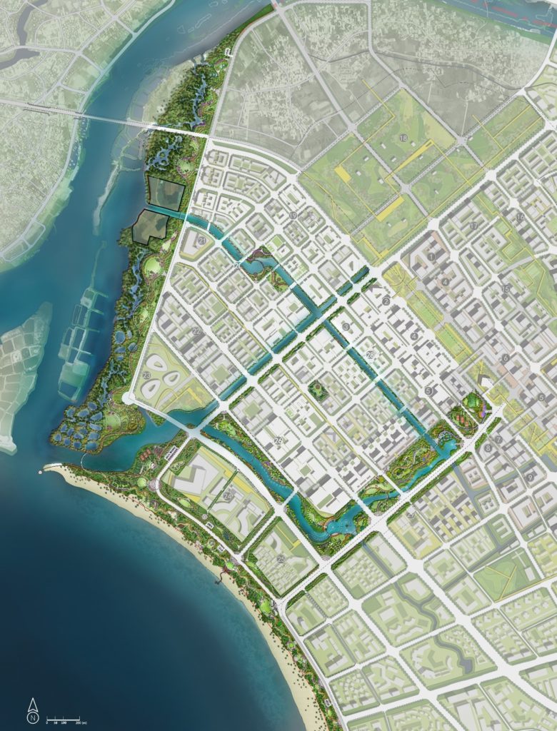
Illustration A – Landscape Concept Masterplan for one of SJ’s project “Ecological Wetland, Resilient Riverfront Park and Coastal Belt at Yazhou Bay, Sanya China”

Q: Please give examples of some project successes that involve the works of Landscape Architecture.

Singapore’s very own “Garden City Vision” was first mooted by then Prime Minister Lee Kuan Yew in 1967 – to transform Singapore into a city with abundant lush greenery and a clean environment to make life more pleasant for the people. The Parks and Trees Act1 in the 1970s mandated Singapore government agencies like the Housing Development Board (HDB) and the Jurong Town Corporation (JTC), as well as private developers, to set aside spaces for trees and greenery in projects such as the development of housing estates, and construction of roads and car parks.

Currently, Singapore’s greening policy is guided by the “city in a garden” vision. Unveiled in 1998 as the next phase of the “garden city” vision, the new concept aimed to integrate greenery into not just the built environment, but also into the daily lives of Singaporeans.

A subset of the “City in a Garden” concept, My Waterway @ Punggol is a 12.25 hectares waterfront park located in the north-eastern part of Singapore. Designed with these thematic zones in mind – nature cove, recreation zone, heritage zone and green gallery, SJ Landscape Team undertook the challenge of transforming a piece of bare land into a 4.2km waterway that meanders through a new town, a Light Rail Transit (LRT) viaduct, two reservoirs and a beautiful waterfront living experience for the residents.

My Waterway @ Punggol (refer to Illustration B) was developed with an aim to bring people closer to water, amongst shared communal spaces, coupled with water-based recreational activities. The residential blocks were even built with an ABC water systems – where rainwater is collected and distributed to the parklands around the waterways.

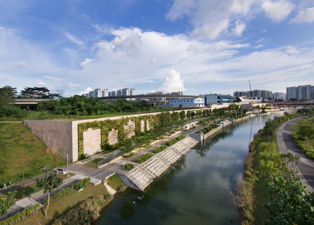
Illustration B – My Waterway @ Punggol

On global playing field and a project undertaken by the team, Yixing Water Ecology in Jiangsu province of China aims to restore the ecology of the area, particularly in the water system, integrated with landscape design (refer to Illustration C). For years, water pollution in the area is a major deterrent for social and economic activities to be carried out. This ‘W-ECO3’ project aims to create a resilient space integrating the surrounding landscapes and water management based on Green & Blue infrastructure design, which emphasizes on sustainable and low-impact development. The team adopted the concept of “001” as guiding principles for the project:

  • Zero (0) contribution to water pollution – potential water pollutant discharge to any public water system will be stringently controlled and removed;
  • Zero (0) impact on flood control – ensure the flood-discharge capacity of all the key flood-discharge channels are not impacted upon in terms of protection and improvement;
  • One (1) clean water source – One Central Wetland with 2.5kmsq area in the masterplan was proposed to produce clean water after treatment. A world-class monitoring technology and Smart IT analysis system has been adopted to manage the cleaned outflow.

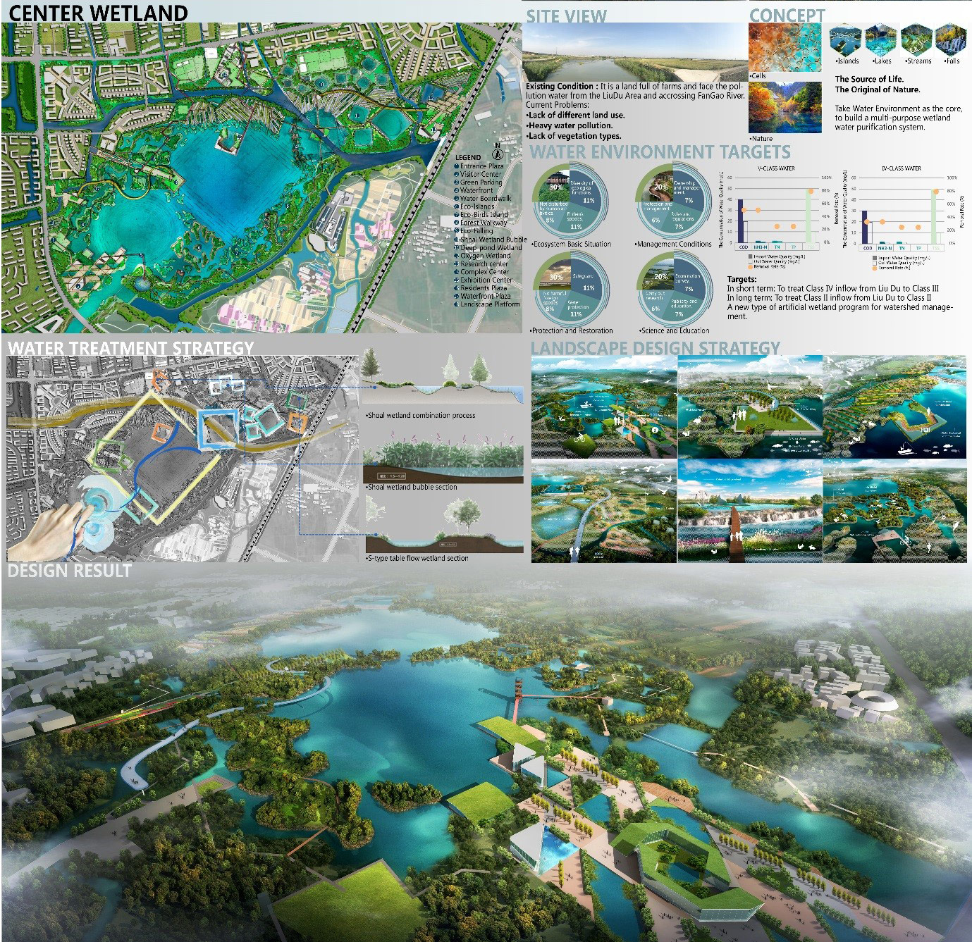
Illustration C – Yixing Water Ecology in Jiangsu province of China (Central Wetland with 2.5kmsq area to produce clean water after treatment)

Q: What do project owners look out for when they engage SJ to do landscape design?

We now know that at master planning and design stage, the landscape architect already plays a pivotal role, which often requires him/her to design key open space components such as community urban plaza, social activities spaces, play spaces and park connectors.

For project works which involve the sensitivity of natural habitats & resources, landscape architects are required to conduct deep research into local people, their culture and lifestyle. The outcome includes well-constructed wetlands, coastal environment, riverfront and green infrastructural projects. The design of such spaces contributes to local identity which brings upon economic, social, and environmental benefits to the local people.

With economic and social viability on the forefront, Ya Zhou Bay in Sanya, China – another recent global project win by SJ’s Landscape Architectural Team – aims to achieve solutioning to urbanism whilst protecting existing ecology (refer to Illustration D). A key criteria of the design concept is to mitigate the risk of ecological extinction caused by natural disasters, pollution and soil erosion.

The Waterfront Eco-Park, which consists of a Coastal Belt Park, Wetland and a Riverfront Park, will be home to a long stretch of windbreak forest with endless coastal entertainment, a wetland reserve preserving ecologically sensitive areas, and an attractive waterfront with large urban and leisure space.

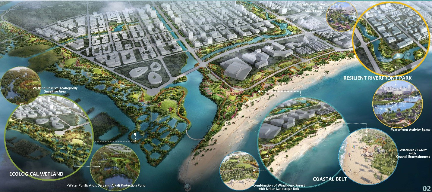
Illustration D – Ya Zhou Bay in Sanya, China

In most, if not all, of our projects, developers are constantly seeking new, sustainable design ideas, and our belief is that no single design solution can be applied across all projects.

Q: What are your views on the future of Landscape Architecture?

It will be dynamic, yet ever-changing – due to the ever-evolving living environment. Climate change also has its effects on how we plan and design our landscape and environment. When the ozone layer is depleting each day, how should we grow our trees and vegetation to ensure we have a holistic cycle to human habitat.

The role of the landscape architect will become even greater, when we move away from the traditional way of planning and designing, and emphasize the importance of green movement and building a resilient environment.

The use of Artificial Intelligence (AI) to achieve landscape analytics, and AI metrics to evaluate spatial impacts of design is the new norm in Landscape Architecture. Amidst combining AI to create sustainable and resilient designs, Green Infrastructure can only be achieved when we start with understanding our natural ecosystem.

** End **

Connect with Us

Oliver Ng Boon Lee

Email: oliver.ngbl@surbanajurong.com

City-Industry Integrated Planning and Development in Singapore

By:
Economic and Industrial Planning Team

Dr Zhang Qingyu
Director

Shao Yong
Senior Executive Planner

Background

City-industry integration is a central tenet of sustainable growth. By integrating diverse land uses, the elements of “industry” and “city” are to be well-balanced within a regional cluster. “Industry” refers to activities involving goods and services producing industries, while “city” refers to residences, commercial facilities and places of leisure, woven seamlessly with nature and waterbodies. On one hand, industrial estates drive employment and attract talents; on the other, towns support and improve the business and living environment of the cluster by providing comprehensive facilities and amenities that meet daily needs of residents.

Singapore has undergone more than 50 years of industrial and urban development, and has achieved considerable success via the adoption of city-industry integration in its planning. The impact of city-industry integrated development model on Singapore’s transformation is exhibited at different scales – Singapore at National Level, West Region and One-North.

City-Industry Integration – Singapore at National Level

Singapore has a clear mission – “to make Singapore a great city to live, work and play in”. This mission was evidently manifested in Singapore’s 1991 concept plan, where the concept of “self-contained cities (regions)-within-a-city” is observed (Figure 1a). Each of the five regions in Singapore was planned to encompass all 3 elements of “live”, “work” and “play”. Employment opportunities from goods and services producing industries was to match job demand from residents of each region, ultimately arriving at a job supply: job demand ratio of approximately 1:1 when the region matures. Meanwhile, an urban transportation system consisting of an integrated road and rail network, has been responsible for the inter and intra connectivity between regions. Figure 1b depicts the latest master plan, which is the result of revisions to previous plans (including Figure 1a) and the translation of broad long-term strategies.

During the initial development stage, goods producing industries constituted the main form of economic activity. With an increase in scale and economic impact, demand for consumer and product services rose to support the entire manufacturing value chain and created a supportive business ecosystem. This facilitated the integration of city functions into industrial-led areas, gradually transforming monotonous industrial estates into vibrant industrial towns with places for leisure activities. Since the 1960s, industrial development, as evidenced by a growth in GDP and GDP per capita, is accompanied by a growth in total constructed land area and total population. As GDP per capita increased from an estimated USD428 in 1960 to USD46,570 in 2010, urban constructed land increased 2.6 times from approximately 162 sqkm to 421 sqkm (of which, industrial area accounts for approximately 76 sqkm and residential area, approximately 91 sqkm). Meanwhile, total population in Singapore grew from 1.65 million in 1960 to 5.08 million in 2010. As detailed in Table 1, each region has varying economic focuses.

Figure 1 – Planning and Development of Singapore

(a) Concept Plan 1991                                                  (b) Master Plan 2014

Planning and Development of Singapore

Table 1 – Increase in Constructed Land Area and Economic Focuses of 5 Regions 

Increase in Constructed Land Area and Economic Focuses of 5 Regions

Note: Figures on constructed land area (including roads) are estimates based on satellite images.


City-Industry Integration – West Region

Spearheading Singapore’s industrial development, the West Region was once a greenfield site that was planned with a port-industry-city integrated development model. Its well-defined land uses allow goods producing industries to enjoy economies of scale while leveraging on a nearby port for cost reduction. Meanwhile, the industries are also being supported by comprehensive residential and commercial facilities, such as shopping malls, banks, universities and hospitals (Figure 2a and 2b). This integrated development advances economic, social and environmental priorities, and has even created a harmonious and conducive wildlife environment. The Jurong Bird Park hosts 400 species, and is Asia’s largest bird paradise; while the western water catchment comprises several reservoirs that harvest urban stormwater for potable consumption. Constructed land in the West region in 1985 was estimated to be 61 sqkm, which increased to 92 sqkm in a decade, and 141 sqkm in 2016 (Figure 2c). The region has proven to be attractive and successful with resident population of approximately 912,000 in 2017, on track to achieving its planned population of 1.13 million.

Figure 2 – Planning and Development of Singapore’s West Region

(a) Port-Industry-City Integrated Development Model                (b) Master Plan 2014 of West Region

Planning and Development of Singapore’s West Region

(c) Development of West Region Over the Years

 Note: Figures on constructed land area (including roads) are estimates based on satellite images.


City-Industry Integration – One-North Development

In line with the 21st century economic focus on knowledge and innovation-intensive industries, the One-North development was conceptualised as a vibrant business park with an integrated work-live-play-learn environment. A microcosm of a self-sustainable city, the master plan of the 200-hectare area integrates industry-centric research, development facilities and business park spaces, alongside lifestyle options and educational institutions, both horizontally and vertically spatially (Figure 3). Residences are provided to meet the needs of employees’ accommodation to the best extent possible. Under the master plan, One-North is to focus on biomedical sciences, infocommunications and media, as well as financial and business services.

With its launch in 2001, One-North has since transformed into a technological and innovation hub that accommodates more than 400 companies with an estimated 46,000 workers (figures is taken as of 2017). Fusionopolis Phase I, designed for the growth of information and communications technologies (ICT), physical sciences and engineering industries, is now an exemplary vertical city. This high-density integrated development has direct access to an MRT station and comprises offices, retail shops, serviced apartments, a health club, and a digital arts theatre. Apart from typical housing options found in One-North and its surrounding areas, the provision of serviced apartments within the building offers high-calibre talents the option for short stays and an array of professional support services.

Figure 3 – Planning and Development of One-North

Planning and Development of One-North


Key Considerations for City-Industry Integrated Development Model in Singapore

Singapore’s journey towards integrating land uses may be summarised into the following key considerations:

Sustainable Industrial Upgrading – Basis of City-Industry Integration

Integrated land use planning is industry-led and industrial upgrading forms its basis and fundamental. Cities grow and increase in population only when industries undergo transformation and upgrading. As industries upgrade, the method of integrating industrial and city functions would need to vary to match the different spatial requirements of different industries. For instance, capital-intensive industries such as the manufacture of machinery and equipment, and petrochemical industries require a larger, continuous tract of land, whereby land parcels are not interspersed with various uses. Meanwhile, knowledge and innovation-intensive industries require space flexibility and more common spaces to facilitate knowledge sharing between professionals.

Matching Employment Opportunities and Job Demand at Different Spatial Scales

To create self-contained regions, an area needs to create employment-generating spaces that offer job opportunities closer to homes. At the regional scale, it is vital to minimally match internal job demand with sufficient job opportunities. This localises daily needs and disperses traffic by reducing the need for people to travel long distances on a regular basis. Set to be the largest commercial and regional centre outside the city centre, the 360 hectares Jurong Lake District in the West Region has transformation plans to create it into a future-ready second CBD. It will not only develop an estimated 20,000 new homes but will also offer more than 100,000 new jobs to residents in the area. For an area of a smaller scale, employment opportunities might not be sufficient to meet job demand but this is to be achieved in its best possible manner.

Attract and Retain Talents by Offering Attractive Facilities and Amenities

City-industry integration is not merely a practical solution to resolving issues such as land scarcity or traffic congestion. It is also about bringing people together, improving their lifestyle and enhancing their everyday experiences. To attract and retain talents necessary to promote sustainable city development, quality and comprehensive public service facilities and commercial services must be provided. From CBD to regional centres, towns, neighbourhoods and precincts, urban functions in Singapore are hierarchically provided to fulfil residents’ living and leisure needs of different age groups. Producer and consumer services are conveniently made accessible to residents within the area, offering great living convenience and sustaining communities for enterprises in the area.

Figure 4 – Comprehensive Facilities and Amenities are Hierarchically Provided at Different Levels

Comprehensive Facilities and Amenities are Hierarchically Provided at Different Levels

Conclusion

Regardless of the economic focus of an area, planning and development in Singapore place great emphasis on integrating its industrial and urban city functions. According to various industry types, different ways of city-industry integration models are adopted to meet varying requirements. The need to balance job supply and demand is also vital in creating a quality and conducive living environment, along with the provision of comprehensive facilities and amenities. As a city lab that constantly reviews its development strategies to fulfill the changing needs of residents, the city-industry integrated development model constantly remains at the core of Singapore’s planning by efficiently utilising available land and reducing the impact of development on the environment, hence strengthening resilience and sustainability of the city.

** End **


Connect with Us

Dr Zhang Qingyu
Email: qingyu.zhang@surbanajurong.com

Shao Yong
Email: shaoyong@surbanajurong.com

References

  • Centre for Liveable Cities. (2016). Insights from the Development Experience of China and Singapore. In CLC, Challenges and Reforms in Urban Governance.Singapore: CLC.
  • Centre for Liveable Cities. (2018). Urban System Studies (1st Edition). In C. Chow, J. Chia, & M. Zhan, Integrating Land Use & Mobility: Supporting Sustainable Growth. Singapore: CLC.

Perspectives, developed by SJ Academy, is our platform to explore new ways of tackling some of today’s most complex challenges. We draw on ideas and opinions from our staff associates and experts across different businesses. Click here to read more about the Workplace of the Future, Singapore’s Logistics, and Aviation Planning in Singapore.

Big potential for city planning in the Middle East

Middle East city urban planning infrastructure industrial consultant firm
The Middle East’s market is “very forward looking” and open to new ideas, says Wong Heang Fine, Group CEO of Surbana Jurong

In the interview with CNBC’s Capital Connection, Mr Wong Heang Fine, Group CEO of Surbana Jurong discussed the company’s operations in the Middle East and the opportunities in the market. Mr Wong shared that technology advances and the rise of the sharing economy will transform the way cities are being planned. Examples of new typology include vertical farming, and co-working and living spaces. https://cnb.cx/2Hs2Jkn

Surbana Jurong Group scores two projects in Zimbabwe

master plan africa
Sharing a victory handshake are SJ’s Issac Assisi and Dr Gideon Gono, Chairman of TD Holdings, after Surbana Jurong and SMEC representatives completed the signing of the master-planning contracts with their clients.

Surbana Jurong’s Planning Group and Economic and Industrial Planning Team, partnering SMEC’s Urbanisation Team in Africa, have jointly secured two project wins in Zimbabwe. The broader service provision will be the Market Positioning, Concept Master Plan, Concept Infrastructure Plan and Development Guide Plan for an 8,000ha Agri-Processing City which includes a 225ha business park situated some 40km from the capital, Harare. The second is the Feasibility Assessment & Concept Master Plan for an Airport Hotel & Wellness Centre Development on the edge of the capital city’s limits. The projects will run concurrently and completion is expected in 10 months.

The projects are wholly aligned with the country’s long-term fiscal objectives to boost much-needed economic activity within a developing, robust Special Economic Zones (SEZ) strategy. Implementation of the newly appointed SEZ Board’s policies will see the two projects showcase not only as pilot schemes but also as important key economic drivers for the capital.

Surbana Jurong wins Chongqing Aerotropolis Township Urban Design competition

chongqing aerotropolis township
The TOD-driven Chongqing Aerotropolis Township design as envisioned by SJ’s Urban Development team in China

Surbana Jurong’s North Asia team has won first prize in Chongqing Aerotropolis Township Urban Design competition, its first transit-oriented development (TOD)-driven design win.

Chongqing is an emerging mega-city in southwest China and, according to a Telegraph report this year, is ranked 8th among the world’s cities with the most number of skyscrapers.

The township, which spans 2.2 km², sits within the 33 km² Chongqing Aerotropolis, with Jiangbei International Airport as the central transportation node.The project scope includes residential, commercial (office/ retail/ F&B), aviation training facilities, healthcare facilities, schools, a neighbourhood centre and parks.

Teo Eng Cheong, CEO, International, notes that the win will put SJ in a good position to pursue design consultancy work downstream for the rest of the aerotropolis.

Surbana Jurong’s big sweep at SIP Planning Awards

SIP Planning Awards
Chief judge Paul Farmer presenting Philip Tan with the awards garnered by the SJ Planning team (right)

Surbana Jurong’s Planning Group (SJPG) has walked away with its biggest haul yet at the SIP Planning Awards.

It snapped up five awards in four categories at the Singapore Institute of Planners’ 5th SIP awards, winning in all the categories it competed. The gala dinner and awards ceremony was held on 21st September 2017 at The Swissotel Merchant Court, where the who’s who in the urban planning fraternity gathered to recognise the industry’s best.

SJ took top spot in three categories – for Best Project for Resilient Planning, Best Planning Project and Best Urban Design Project.

Philip Tan, Managing Director of the Urban Planning Group called this “a great milestone for the five projects competing among 59 other project entries by local and foreign consultants”.

He added, “SJPG has been consistently winning these awards since the programme was first inaugurated in 2008, a testament that SJ is at the forefront creating value in planning cities and also representing the Singapore brand experience in planning townships, where Singapore is widely known to be the innovative and leading showcase to many international communities.”

On the judging panel were W. Paul Farmer (past president, American Planning Association), Fong Chun Wah (Deputy CEO, HDB), Hwang Yu Ning (Chief Planner, URA), and Mohinder Singh (Dean, LTA Academy).

SJ winners at the SIP awards 2017
Project Category Award
Social Resilient Plan for Amaravati, India Best Project for Resilient Planning Gold
Northern Savannah Ecological Zone (NSEZ) Regional Concept Plan, Ghana Best Planning Project Gold
Kaloum Redevelopment Master Plan 2040, Conakry Guinea Best Urban Design Project Silver
(no Gold was awarded)
Mwanza City Master Plan, Tanzania Best Planning Project Bronze
Arusha City Centre Urban Design, Tanzania Best Urban Design Project Merit

Sharing insights at the World Cities Summit events in Suzhou

World Cities Summit Suzhou
CEO, North Asia, Michael Ng (on screen, first from the right) addressing delegates at this year’s World Cities Summit Mayors Forum

Last week, Surbana Jurong showcased its thought leadership at the World Cities Summit (WCS) Mayors Forum and the World Cities Summit Young Leaders (WCSYL) Symposium held in China.

Hosted by the city of Suzhou, mayors, international organisations and industry leaders from cities across Africa, Asia, Europe, Latin America, the Middle East and the Oceania gathered to share best practices and urban innovations that promote liveable and sustainable cities.

The Forum is co-organised by Singapore’s Centre for Liveable Cities and the Urban Redevelopment Authority and is a flagship event of the WCS, which is held in Singapore biennially.

The global platform was a great opportunity for our experts to share their insights and position SJ as a thought leader in urbanisation, industrialisation and infrastructure development.

This year’s Mayors Forum was themed “Liveable and Sustainable Cities: Embracing the Future through Innovation and Collaboration”. Michael Ng, CEO, North Asia, shared his views on the importance of sustainable development as well as SJ’s strategy for development in East Asia.

Tan Szue Hann, Head, Sustainability and Tan Eng Kiat, Senior Principal Planner, Urban Planning, Singapore attended the concurrent World Cities Summit Young Leaders (WCSYL) Symposium, where a select group of change-makers from diverse sectors met to discuss and tackle urbanisation challenges.They engaged with Young Leaders from Singapore and other cities and initiated potential collaboration on sustainability projects.

Szue Hann and Eng Kiat are both members of the WCSYL, an invite-only professional network which provides a platform for discourse on urban issues.

They also had the opportunity to exchange views with Singapore’s Minister for National Development Lawrence Wong on culture and heritage and its influence on planning and urbanisation.

Tan Szue Hann sustainability

Head of Sustainability Tan Szue Hann (second from right) leading group discussions at the Young Leaders Symposium

Tan Eng Kiat urban planning

Senior Principal Planner, Urban Planning Tan Eng Kiat (seated left) having a discussion at the Young Leaders Symposium