


A Sustainable Approach to Improve Water Supply for Underprivileged Communities

A Case Study on Myaungmya Township, Myanmar
Introduction
Access to clean water remains a challenge for many rural communities. In Myanmar, one-third of rural homes lack improved water supplies, which is linked to poverty, lower health, and higher mortality. While there are efforts to develop adequate water infrastructure, some challenges remain in the search for low-cost sustainable solutions catered to the livelihood of the rural communities.
For one, rural water infrastructure projects can often lack consultancy input throughout its life-cycle due to financial constraints. There is a lack of incentive for innovation due to the high cost of failure, which results in ineffective solutions being perpetuated, causing inefficient usage of funding and resources. While certain solutions do work in the context of the rural landscape, it is also essential to continue the search for more effective and low-cost solution, in order to maximise the use of their limited resources to benefit a larger community.
Secondly, while modern water technology is effective in improving water access in urban cities, it cannot be simply transferred to the rural landscape without serious consideration of its appropriateness. Rural settlements generally consist of smaller and remote villages, where economical decentralised solutions are sought after as compared to large infrastructure projects that can be more financially feasible and/or accommodate technologically savvy solutions due to economies of scale. Therefore, consultancy service could be essential to achieve site specific applications.
Finally, local water supply is also often diversified due to distinct dry-wet season variations. Hence, water resource assessment is a crucial part of the planning process to determine the amount of water hydrologically available, supported by modern computational tools. Lastly, capacity building is critical for such community work to improve water resiliency. Proper planning and consultancy efforts would ensure multiple dimensions are adequately addressed to meet the needs of the local community.
Here, Surbana Jurong was engaged to provide consultancy service by an international non-profit organisation that is committed to enabling sustainable access to clean water and sanitation for Asia’s rural poor. In this case study, Surbana Jurong is tasked to provide engineering services for increasing water supply across 9 villages in Myaungmya Township in the Ayeyarwady region. The villages are scattered across the Myaungmya Township in largely remote rural settings, and rely on a variety of water sources throughout the years. Rainwater harvesting is adopted by most of the villages, and traditional methods to increase the water supply generally involved the construction of new earthen rainwater harvesting ponds and water storage tanks, or the expansion of existing ponds. Here, Surbana Jurong seeks to enhance the traditional solutions through conducting detailed site studies and designing improved rainwater harvesting and storage infrastructure that will be piloted in these locations.
The team investigated two main approaches to meet the required water increment targets:
- Water Loss Reduction: Reducing the main sources of water loss (evaporation/seepage)
- Water Volume Increment: Increasing the volume of water collected through increasing the rainfall catchment area of the pond)
To gain a deeper appreciation of each location’s site context, site specific data (meteorological data, topographical data, water quality test results, village interviews and material availability) was collected. A Water Quality Index is proposed to develop an objective baseline to compare the water quality across different water sources and serve as an effective communication tool to the stakeholders. Computational tools such as the Stormwater Management Model and Computational Fluid Dynamics were utilised by the team to analyse the water storage depletion and wind flow pattern upon implementation of various solutions. Finally, a set of low-cost and innovative solutions was developed for potential trial and implementation in the villages. A decision tree is used for initial solution selection, and lifecycle analysis is further adopted to select the most cost efficient solutions over a specified design lifecycle. The similar methodology can be developed for any regions to suit the water target requirements.
1. Main Approaches to Increasing Rainwater Harvesting Water Supply
1.1 Approach 1 – Water Loss Reduction
To look at water loss reduction for the ponds, establishing a baseline of the main sources of water loss is essential for the design. Here, 2 main sources of water loss are critical:
- Traditional design for rainwater harvesting pond are open air for direct collection of rainwater – significant water evaporation loss during the dry season where the sun is most intense.
- The existing ponds are also simple dug out ponds with a layer of compacted soil and no waterproof linings – seepage loss could be a concern for such ponds.
Hence, the baseline of the two main sources of water loss (Evaporation and Seepage) are explored in greater detail based on site specific data (e.g. wind, rainfall, evaporation).
1.1.1 Analysis of Evaporation Loss
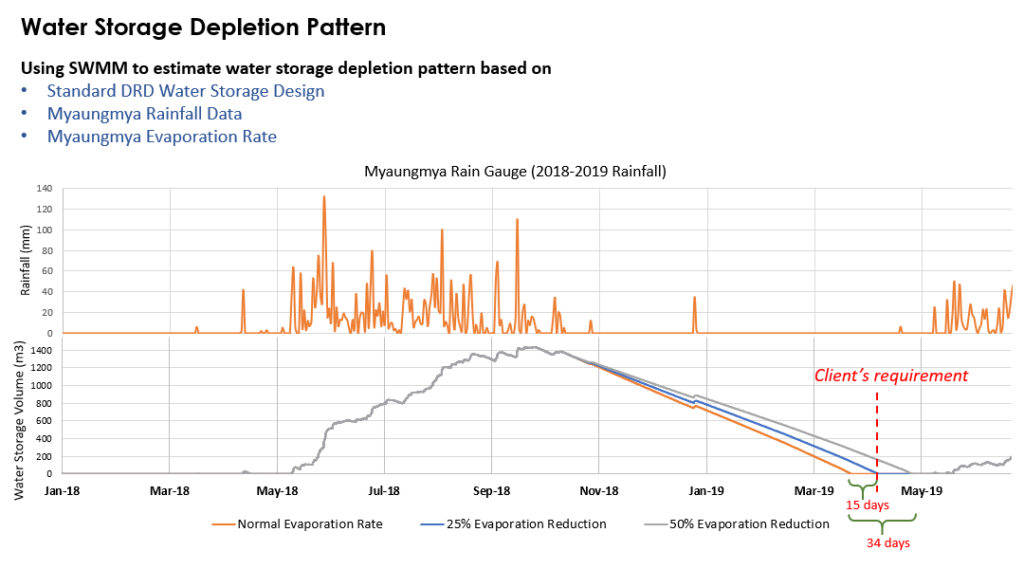
Evaporation is the main cause of water loss ranging from 92 mm to 163 mm on a monthly basis, where it accounts for 30-40% of the total water loss during the dry season, over a period of six months. To determine the critical value for evaporation loss reduction, a water storage and depletion modelling is developed based on a standard pond design. The result of the depletion is plotted in Figure 1. With no evaporation reduction measures, the storage pond will be depleted by early April, in line with village observation. A minimum of 25% evaporation rate reduction with the water supply could extend the water source for another 15 days, and a 50% reduction in evaporation rate could extend the water supply for 34 days close to near the end of the dry season.
Figure 1: Myaungmya water storage depletion result with evaporation reductionWith a baseline of the evaporation rate established, solutions that can potentially reduce the evaporation rate is further explored. Two main sources of evaporation are assessed:
- Wind evaporation (Vapor pressure at water surface)
- Solar evaporation (Latent heat of water)
1.1.1.1 Solutions Targeting Evaporation Loss – CFD Study for Active and Passive Wind Reduction
Large winds will accelerate water evaporation as the wind carries away the water molecules, lowering air humidity which allows for more water to evaporate. Hence, methods that can block and reduce the wind velocities are tested. A Computational Fluid Dynamics (CFD) modelling – i.e. numerical simulation to solve fluid (in this case, air) flow is performed to assess the impact of a change in the shape, orientation, fencing location on the wind velocities to arrive at a recommended solution.
Wind Records collected from the Myanmar Department of Meteorological & Hydrology (DMH), found the most common wind direction derives from the West, Northwest and Northeast. The average wind velocity lies around 2mph (0.9m/s), a low value which suggest that wind evaporation is not a significant concern for the township. The maximum wind speed goes up to 5 – 6 mph (~2m/s) during the dry season, and a CFD study is developed based on these parameters of the worst-case condition.
Figure 2 shows some results of the CFD cases. Upon a curious challenge by the client on the effect of orientation, without the CFD model, the team was unable to intuitively identify that the natural embankment (which serves as a passive wind shield) is not able shield the west wind at an angle. This was an important finding that led to a further modelling on various parameters to arrive at a unified guideline for pond siting.
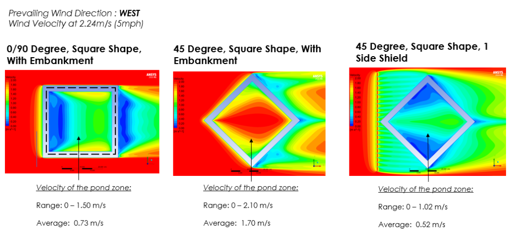
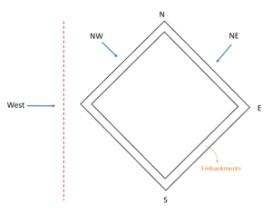
Although the CFD study provides a recommended option, the application for each village has to be assessed independently. For existing ponds following a fixed land plot, it is not ideal to change the orientation of the pond and make full use of the land plot provided for pond improvement works to gain the maximum amount of water from the given plot. The orientation guideline is best suited for new ponds due to flexibility in siting and orientating the pond before construction.
1.1.1.2 Solutions Targeting Evaporation Loss – Solar Evaporation Reduction
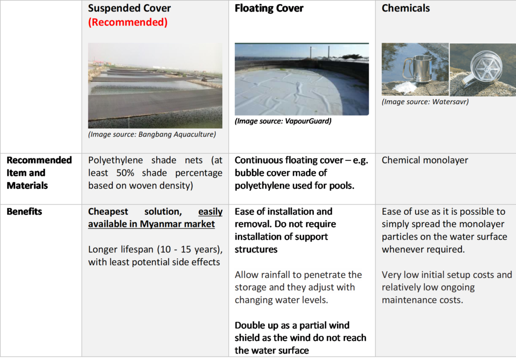
Low-cost measures primarily targeting at reducing solar evaporation are considered. Three methods of evaporation reduction – Suspended Cover, Floating Cover and Chemical Monolayers, are considered, with a comparison as shown in Table 1. For the local context of the Myaungmya Township, it is most recommended to provide a Suspended Shade Cover for evaporation reduction, due to the high cost-effectiveness in the long term. The solution is inexpensive to build and maintain. Although the trade-off involves the required labour to erect and remove the shade cover every season, it is likely a more acceptable solution for the locals as it only adds external structures for the pond, instead of impacting the water directly.
1.1.2 Analysis of Seepage Loss
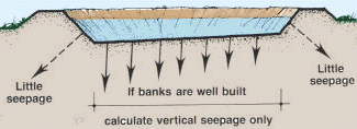
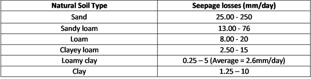
Seepage loss occurs when water is lost vertically through the bottom of the pond, horizontally through the dikes/ embankment by infiltration, or backflowing through the drainage system of the pond. For a well-built pond, vertical seepage is likely of greater concern and will depend on the soil texture and on the soil structure of the pond bottom (Figure 4).
Based on field observation of the type of soil in the current villages, the common soil type used for the ponds are close to the “Loamy clay” or “Clay” type soil with lower seepage. However, even with these better soil type, there could still be significant losses amounting to about 30% of the total water loss (assuming 2.6mm/day for loamy clay) if no seepage control measures are implemented.
To address the seepage concern for new and existing ponds dug directly into the soil, two main solutions are considered involving a natural clay liner and a synthetic geo-liner.
1.2 Approach 2 – Water Volume Increment
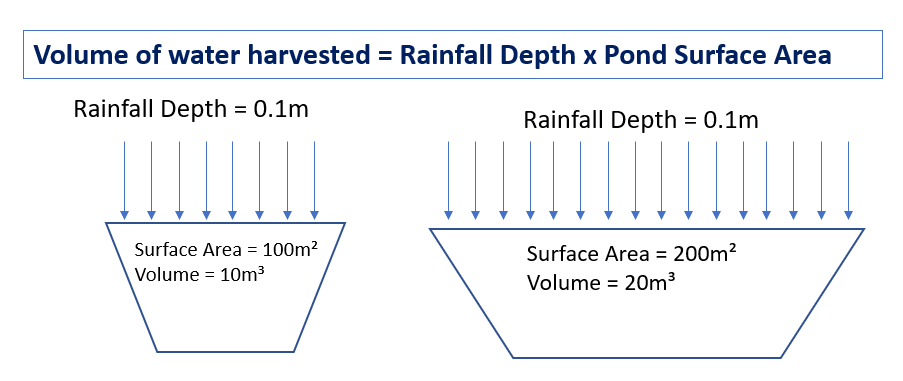
The second approach to maximising rainwater harvesting is to increase the catchment area, as the volume of rainwater collected is a function of the rainfall depth and the catchment area (Figure 5). Developing a rainwater drainage system to collect the surface runoff is not advisable due to the large possibility of collecting pesticides and dirt/silt contaminated rainwater. Hence, increasing the catchment surface area that collects direct rainfall would be the recommended approach for enhancement. This minimises the potential ground contamination to maintain the water quality.
1.2.1 Solution Targeting Catchment Area Increment
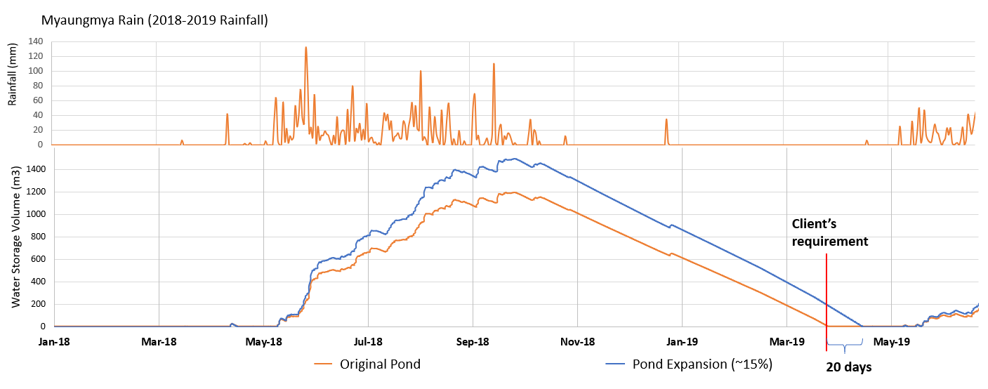
For large and clustered communities where a shared communal pond can be implemented as an accessible and cost-effective source of water supply, a predominant method of increasing the rainwater catchment area involves shifting the existing pond embankments back or expanding the entire pond to increase both the pond’s catchment area and storage capacity (Figure 6). An alternative method would be to build an artificial “catchment” outside of the pond area using certain types of sheet or scaffolding structure to channel rainfall into the pond. A tailored design would have to be developed for individual villages based on their original pond size to meet the water target requirements.
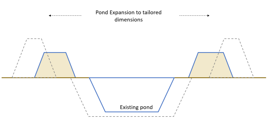
However, it is to be noted that the increase in catchment area and storage area with pond expansion is accompanied by a corresponding increase in the evaporation rate and seepage loss. The pond volume increment should exceed the increase in losses over the dry season in order to secure additional water supply. One village is shown as an example where a 15% pond area expansion from the original pond area can increase the water collected to meet the Client’s requirement and extend the water supply by 20 days, whilst accounting for the seepage and evaporation loss increment (Figure 7).
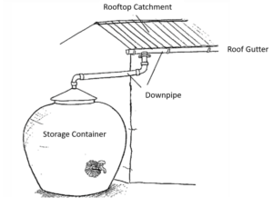
For scattered community clusters where constructing a communal water storage facility is not optimal (lack of available land and accessibility), individual household rooftop rainwater harvesting is designed to improve their access to clean water supply (schematic as shown in Figure 8). Although direct rainfall collection is preferred, the surface area of the individual storage tanks units is too small to collect a substantial volume of rain (up to a maximum of 3m2, compared to a typical pond size of 900m2) and provisioning an excessively large tank would not be feasible in terms of potability and maintenance at the household level. The rooftop adds a larger ‘rainfall catchment area’ where the rainwater that falls on the roofs would be drained into the storage tank via a series of roof gutters and downpipes, thus reducing the time taken for the tanks to be filled up. This would be especially useful towards the end of the wet season where rainfall intensity reduces significantly, and a larger catchment area would maximise rainwater collection.
1.2.2 Additional Solutions for Unique Site Conditions
The analysis and development of solutions are largely catered to improving new and existing rainwater storage ponds. However, the construction or expansion of a pond may not be suitable for all villages due to constraints in site conditions. Other potential water storage facilities are also explored, such as a storage tank design made of ferro-cement or Reinforced Concrete (RC) as potential materials to address issues of unfavourable site conditions (e.g. irregular land plots, sloping land, and permeable soil) as they can be cast into the required shapes and designed to be structurally strong through providing proper strutting and intermediate supports.
2. Water Quality Index for Effective Communication
Lastly, to encourage more active water quality monitoring, we have proposed the use of a Water Quality Index to establish a baseline and generate greater awareness of the state of the water sources.
The National Sanitation Foundation Water Quality Index (NSFWQI)[1] is an international standard of water quality assessment based on a standard 9 water quality parameters supported by rigorous research globally. The aim of WQI is to give a single value to water quality of a source, resulting in easy interpretation of water quality monitoring data. It enables a fair and objective comparison of water quality between multiple sampling sites and time, and helps to facilitate communication with lay person like local residents.
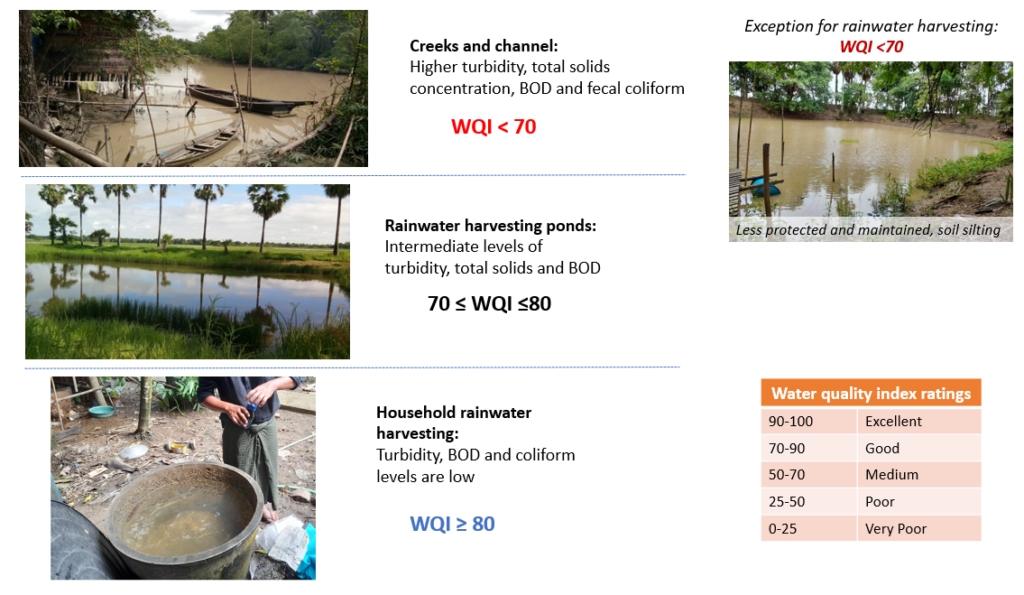
Based on the WQI results, we would be able to assign an index value for the water quality of specific water source, which generally corresponds to the actual site conditions as shown in Figure 10.
- Generally, the creeks and channels have a worse water quality (lower WQI value) than other sources due to higher turbidity, total solids concentration, BOD and fecal coliform in the water sample. Exposed murky waters is observed, possibly due to rural practises of discharging their waste directly into the creeks.
- Rainwater harvesting sources have better water quality, with intermediate levels of turbidity, total solids and BOD concentration. Some ponds are of exception possibly due to low protection and soil silting, and this can serve as an educational example to show the importance of proper maintenance of the pond.
- Household-level rainwater harvesting, (i.e. collecting rainwater in ceramic or plastic pots for individual households use), have best water quality (excellent WQI values) , and is represented with a lower turbidity, BOD and coliform levels in the water. These waters are generally well-protected from contamination (such as from animal feces, soil silting).
As the WQI results can be easily interpreted by the local residents, this can be an effective channel to educate the villagers of the benefits of using rainwater harvesting systems (low-cost and better water quality) of increasing the water supply, and on the protection of their water systems from contamination.
[1] For more information on the WQI, please refer to:
Mr. Brian Oram, P. Monitoring the Quality of Surface Waters (WQI Calculator). Retrieved from Water Research Center.
Mirzaei, Mojgan & Mahini, & Solgi, Eisa. (2016). Evaluation of surface water quality using NSFWQI index and pollution risk assessment using WRASTIC index in 2015.. Arch Hyg Sci. 5. 264-277.
3. Solution Selection Decision Matrix
The above study for water depletion and evaporation control brings the team to 5 potential solutions in combination of the various study that has been developed:
- Solar Shield (Evaporation)
- Pond Expansion (Catchment area and storage capacity increase)
- Structural scaffolding (Catchment area increase)
- Water Storage tanks – Reinforced concrete or ferro-cement tank (Unique site conditions)
- Geo-liner (Seepage)
These 5 solutions are considered in tandem with the original solutions of expanding the pond and constructing new pond in each village.
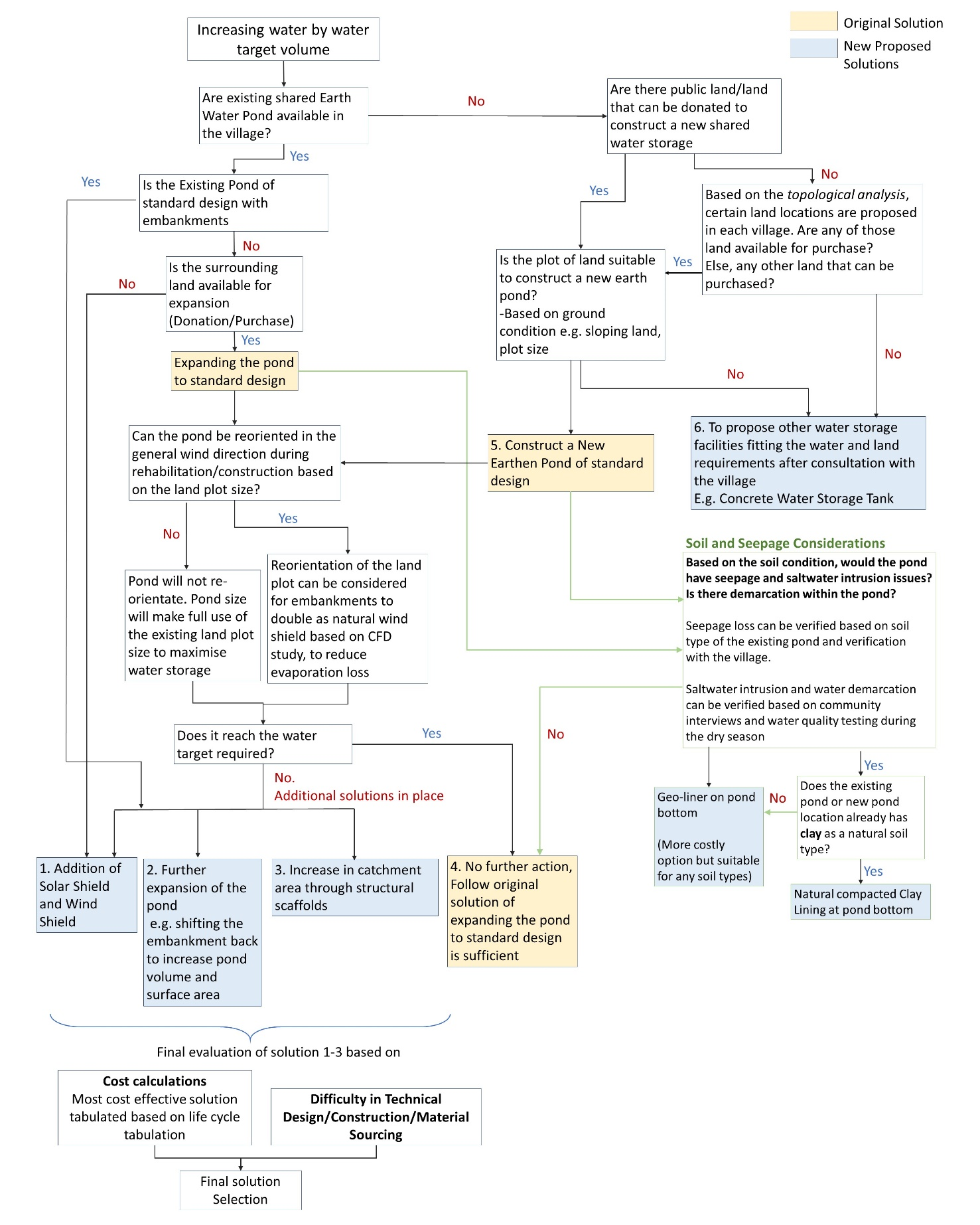
Hence, Surbana Jurong has also developed a decision tree qualifying the various steps in the recommendation of the final solution for each village.
Various considerations are assessed:
- If the village do not own an existing rainwater harvesting facility for rehabilitation, provisioning an entirely new water storage such as new earth pond or new tank facilities would immediately be the priority solution.
- If the pond is already of a significant size equal or greater than the standard recommended pond design (which further expansion could lead to maintenance and operational difficulties), other solutions to meet the water target should also be considered such as implementing a solar shield to reduce evaporation, or external scaffolding to increase the catchment area.
- If there are major conflicting land issues in expanding the pond or building a new water storage facility, solutions which require the least amount of land is of greater priority, such as constructing a concrete tank of customised dimensions which takes up lesser space.
- Seepage loss and saltwater considerations should be assessed for all new and existing earth ponds by assessing the soil conditions and the water quality of the pond during the dry season. A pond liner should be provided during rehabilitation and construction to reduce the seepage and salinity in the pond to maintain a good water volume and quality.
These considerations are summarised within a decision tree (Figure 10) to allow for a quick review of the various considerations to select the best course solution in meeting the required water target.
The designs of the solution are further assessed based on the lifecycle cost – i.e. total cost of ownership over the lifetime of an asset. The communal solutions are evaluated based on a 20 years lifecycle, while the household solutions are calculated based on a 10-year lifecycle, in consideration of the new technologies in the future that may replace the current structures. This allows the team to filter the material or designs that may not be sustainable within the solution’s designated lifecycle. For instance, for soil bank protection, although Gunny rolls are considered one of the least expensive material in terms of the upfront cost, it requires to be replaced every year and would potentially lead to a higher lifecycle cost over 20 years compared to the alternative, higher capital options such as the Geo-synthetic Clay Liner that could last 20 years without replacement.
Finally, the potential for developed solutions to be scaled and replicated by local stakeholders would be an important determining factor. This involves if the material is available locally (e.g. for frame structures, bamboo or timber is used depending on which material are available locally in the village), and the ease of local design, construction and maintenance.
The selection methodology illustrated is applicable not only for the 9 villages in the Myaungmya Township, but also for future implementation where the client and the government can decide on the best course of action to improve the water supply in other villages.
4. Conclusion
Technical inputs of the Surbana Jurong team allows for adequate selection and optimised design of various low-cost solutions for the villages, whilst ensuring efficient water resource planning.
Two main approaches (Water Savings and Water Volume Increment) are explored to develop potential low-cost solution to increase the water supply, which value-adds to the existing solution of the villages.
For water savings, methods to reduce evaporation and seepage loss are developed. The wind CFD study provide a versatile guideline for the optimal placement of the pond and can be easily adapted to other areas based on the site-specific meteorological data, while the evaluation of various options of solar shield found suspended shield cover as the most economical solution for the township with high effectiveness and locally available materials. For seepage loss reduction, a geo-liner is recommended to address seepage and soil intrusion issues which can be provisioned regardless of the soil condition.
For water volume increment, methods to increase the direct rainwater collection is explored such as pond expansion and structural scaffolding to achieve tailored solution for each individual village. Water supply modelling is used to model the water supply pattern in the pond based on local rainfall, evaporation and seepage information, which enables the team to predict the effectiveness of various solutions during the conceptual stage.
The water quality index ensures a fair and objective comparison across different water sources and for effective stakeholders communication.
A decision tree is developed by the SJ team which qualifies the various site constraints in the final solution selection. Lifecycle cost analysis is used to select the most cost-efficient designs and materials over the specified duration of service, and the ease of replication or scaling up of the design is also assessed before the final solution is selected f each village.
The team believes that this research approach can be scaled up and conducted across various environments with differing weather conditions and geographies, to assess and inform the design of cost-efficient water supply solutions for the targeted communities.
Contributed By:
Chan Hui Ling, Engineer, Sustainability and Resiliency Office, Surbana Jurong Consultants Pte Ltd
Trivin Chua Meng Guan, Executive Project Manager / Project Team Lead, Surbana International Consultants Myanmar Co Ltd
Swe Thet Maung, Principal Engineer (Infrastructure & Geotechnical Team Lead), Surbana International Consultants Myanmar Co Ltd
Victor Sim Siang Tze, Head of Resiliency, Sustainability and Resiliency Office, Surbana Jurong Consultants Pte Ltd
Ravelth Belicena, Senior HR and Admin Associate / Deputy Project Team Lead, Surbana International Consultants Myanmar Co Ltd